
Harpers Ferry topographic map
Interactive map
Click on the map to display elevation.
About this map
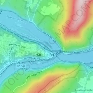
Name: Harpers Ferry topographic map, elevation, terrain.
Average elevation: 174 m
Minimum elevation: 71 m
Maximum elevation: 421 m
The town was "easy to seize, and hard to hold", because of its topography: surrounded on three sides by high ground – Bolivar Heights to the west, Loudoun Heights to the south, and Maryland Heights to the east – and surrounded by the Potomac and Shenandoah Rivers, anyone who controlled the heights controlled the city.
Other topographic maps
Click on a map to view its topography, its elevation and its terrain.
Shepherdstown
United States > West Virginia > Jefferson County
Shepherdstown, Jefferson County, West Virginia, 25443, United States
Average elevation: 126 m
Kearneysville
United States > West Virginia > Jefferson County > Kearneysville
Kearneysville, Jefferson County, West Virginia, 25430-9047, United States
Average elevation: 162 m
Harpers Ferry National Historical Park
United States > West Virginia > Jefferson County > Bolivar
Harpers Ferry National Historical Park, Bolivar, Jefferson County, West Virginia, United States
Average elevation: 161 m
Charles Town
United States > West Virginia > Jefferson County
Charles Town, Jefferson County, West Virginia, United States
Average elevation: 150 m
Halltown
United States > West Virginia > Jefferson County > Halltown
Halltown, Jefferson County, West Virginia, 25423, United States
Average elevation: 133 m
Ranson
United States > West Virginia > Jefferson County
Ranson, Jefferson County, West Virginia, 25438, United States
Average elevation: 161 m