
Caboolture topographic map
Interactive map
Click on the map to display elevation.
About this map
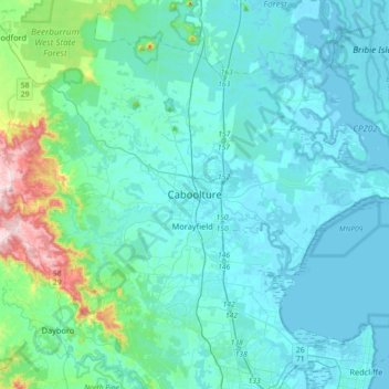
Name: Caboolture topographic map, elevation, terrain.
Location: Caboolture, Queensland, 4510, Australia (-27.24393 152.79109 -26.92393 153.11109)
Average elevation: 60 m
Minimum elevation: -2 m
Maximum elevation: 494 m
Other topographic maps
Click on a map to view its topography, its elevation and its terrain.
Moreton Island
Australia > Queensland > Caboolture
Moreton Island, Caboolture, Queensland, Australia
Average elevation: 7 m