
Bir El Arch topographic map
Interactive map
Click on the map to display elevation.
About this map
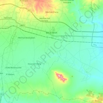
Name: Bir El Arch topographic map, elevation, terrain.
Location: Bir El Arch, Daïra Bir El Arch, Sétif, Algérie (36.02129 5.74233 36.18108 5.88210)
Average elevation: 946 m
Minimum elevation: 877 m
Maximum elevation: 1,181 m
Other topographic maps
Click on a map to view its topography, its elevation and its terrain.
Mechtat el Gasria
Algérie > Sétif > Daïra Bir El Arch > Belaa > Mechtat el Gasria
Mechtat el Gasria, Belaa, Daïra Bir El Arch, Sétif, Algérie
Average elevation: 963 m