
Tsabong topographic map
Interactive map
Click on the map to display elevation.
About this map
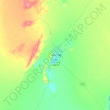
Name: Tsabong topographic map, elevation, terrain.
Location: Tsabong, Kgalagadi District, Botswana (-26.18175 22.24101 -25.86175 22.56101)
Average elevation: 983 m
Minimum elevation: 954 m
Maximum elevation: 1,040 m
Other topographic maps
Click on a map to view its topography, its elevation and its terrain.
Kgalagadi Transfrontier Park
Kgalagadi Transfrontier Park, Kgalagadi District, Botswana
Average elevation: 1,021 m
Bokspits
Botswana > Kgalagadi District > Bokspits
Bokspits, Kgalagadi District, Botswana
Average elevation: 860 m