
City of Ekurhuleni Metropolitan Municipality topographic map
Interactive map
Click on the map to display elevation.
City of Ekurhuleni Metropolitan Municipality
Ekurhuleni lies on the highveld plateau at about 1600 metres in altitude above sea level (asl). The highest elevation is at the Gillooly's Ridge – Bill Stewart Side – Fisher's Hill at 1772 metres asl. The lowest point is at 1552 metres asl. The city is rich in wetlands, pans, streams and rivers. The city is highly urbanised; however, the north especially has high-potential agricultural land.
About this map
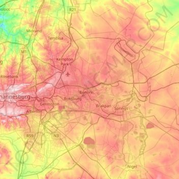
Name: City of Ekurhuleni Metropolitan Municipality topographic map, elevation, terrain.
Average elevation: 1,588 m
Minimum elevation: 1,360 m
Maximum elevation: 1,808 m
Other topographic maps
Click on a map to view its topography, its elevation and its terrain.
Sandton
South Africa > Gauteng > City of Johannesburg Metropolitan Municipality
Average elevation: 1,583 m
Johannesburg
South Africa > Gauteng > City of Johannesburg Metropolitan Municipality
Johannesburg is located in the eastern plateau area of South Africa known as the Highveld, at an elevation of 1,753 metres (5,751 ft). The former Central Business District is located on the southern side of the prominent ridge called the Witwatersrand (English: White Water's Ridge) and the terrain falls to the…
Average elevation: 1,615 m
Pretoria
South Africa > Gauteng > City of Tshwane Metropolitan Municipality
Pretoria is situated approximately 55 km (34 mi) north-northeast of Johannesburg in the northeast of South Africa, in a transitional belt between the plateau of the Highveld to the south and the lower-lying Bushveld to the north. It lies at an altitude of about 1,339 m (4,393 ft) above sea level, in a warm,…
Average elevation: 1,363 m
Centurion
South Africa > Gauteng > City of Tshwane Metropolitan Municipality
Average elevation: 1,451 m
Johannesburg
South Africa > Gauteng > City of Johannesburg Metropolitan Municipality
Johannesburg is located in the eastern plateau area of South Africa known as the Highveld, at an elevation of 1,753 metres (5,751 ft). The former Central Business District is located on the southern side of the prominent ridge called the Witwatersrand (English: White Water's Ridge) and the terrain falls to the…
Average elevation: 1,615 m
Kempton Park
South Africa > Gauteng > City of Ekurhuleni Metropolitan Municipality
Average elevation: 1,654 m
iKhaya LamaDube Lodge
South Africa > Gauteng > City of Tshwane Metropolitan Municipality
Average elevation: 1,146 m
Emmarentia Fountain
South Africa > Gauteng > City of Johannesburg Metropolitan Municipality > Johannesburg
Average elevation: 1,612 m
Benoni
South Africa > Gauteng > City of Ekurhuleni Metropolitan Municipality
Average elevation: 1,645 m
Centurion
South Africa > Gauteng > City of Tshwane Metropolitan Municipality
Average elevation: 1,451 m
Randburg
South Africa > Gauteng > City of Johannesburg Metropolitan Municipality
Average elevation: 1,567 m
Johannesburg
South Africa > Gauteng > City of Johannesburg Metropolitan Municipality
Johannesburg is located in the eastern plateau area of South Africa known as the Highveld, at an elevation of 1,753 metres (5,751 ft). The former Central Business District is located on the southern side of the prominent ridge called the Witwatersrand (English: White Water's Ridge) and the terrain falls to the…
Average elevation: 1,615 m
Sandton
South Africa > Gauteng > City of Johannesburg Metropolitan Municipality
Average elevation: 1,583 m
Sandton
South Africa > Gauteng > City of Johannesburg Metropolitan Municipality
Average elevation: 1,583 m
Midrand
South Africa > Gauteng > City of Johannesburg Metropolitan Municipality
Average elevation: 1,542 m
Roodepoort
South Africa > Gauteng > City of Johannesburg Metropolitan Municipality
Average elevation: 1,593 m
Pretoria
South Africa > Gauteng > City of Tshwane Metropolitan Municipality
Pretoria is situated approximately 55 km (34 mi) north-northeast of Johannesburg in the northeast of South Africa, in a transitional belt between the plateau of the Highveld to the south and the lower-lying Bushveld to the north. It lies at an altitude of about 1,339 m (4,393 ft) above sea level, in a warm,…
Average elevation: 1,363 m
Johannesburg Botanical Gardens
South Africa > Gauteng > City of Johannesburg Metropolitan Municipality > Johannesburg
Average elevation: 1,633 m
Boksburg
South Africa > Gauteng > City of Ekurhuleni Metropolitan Municipality
Average elevation: 1,637 m
Emmarentia Dam
South Africa > Gauteng > City of Johannesburg Metropolitan Municipality > Johannesburg
Average elevation: 1,611 m
Johannesburg
South Africa > Gauteng > City of Johannesburg Metropolitan Municipality
Johannesburg is located in the eastern plateau area of South Africa known as the Highveld, at an elevation of 1,753 metres (5,751 ft). The former Central Business District is located on the southern side of the prominent ridge called the Witwatersrand (English: White Water's Ridge) and the terrain falls to the…
Average elevation: 1,615 m
Thembisa
South Africa > Gauteng > City of Ekurhuleni Metropolitan Municipality
Average elevation: 1,594 m
Nigel
South Africa > Gauteng > City of Ekurhuleni Metropolitan Municipality
Average elevation: 1,570 m
Daveyton
South Africa > Gauteng > City of Ekurhuleni Metropolitan Municipality
Average elevation: 1,613 m
Springs
South Africa > Gauteng > City of Ekurhuleni Metropolitan Municipality
Average elevation: 1,606 m
Springs
South Africa > Gauteng > City of Ekurhuleni Metropolitan Municipality
Average elevation: 1,606 m
Alberton
South Africa > Gauteng > City of Ekurhuleni Metropolitan Municipality
Alberton lies at an elevation of approximately 1,570 m (5,150 ft) above sea level on the banks of the Natal Spruit, approximately 11 km south-east of Johannesburg CBD, 59 km south of Pretoria and 49 km north-east of Vereeniging. Organisationally and administratively, it is included in the City of Ekurhuleni…
Average elevation: 1,617 m
Soweto
South Africa > Gauteng > City of Johannesburg Metropolitan Municipality
Average elevation: 1,638 m
Midrand
South Africa > Gauteng > City of Johannesburg Metropolitan Municipality
Average elevation: 1,542 m
Bass Lake
South Africa > Gauteng > Sedibeng District Municipality > Midvaal Local Municipality
Average elevation: 1,473 m
Mamelodi
South Africa > Gauteng > City of Tshwane Metropolitan Municipality
Average elevation: 1,319 m
Meyerton
South Africa > Gauteng > Sedibeng District Municipality > Midvaal Local Municipality
Average elevation: 1,479 m
Ennerdale
South Africa > Gauteng > City of Johannesburg Metropolitan Municipality
Average elevation: 1,630 m
George Hay Park
South Africa > Gauteng > City of Johannesburg Metropolitan Municipality > Johannesburg
Average elevation: 1,648 m
Ga-Rankuwa
South Africa > Gauteng > City of Tshwane Metropolitan Municipality
Average elevation: 1,227 m
Emmarentia Dog Park
South Africa > Gauteng > City of Johannesburg Metropolitan Municipality > Johannesburg
Average elevation: 1,641 m
Sharpeville
South Africa > Gauteng > Sedibeng District Municipality > Emfuleni Local Municipality
Average elevation: 1,459 m
Lenasia
South Africa > Gauteng > City of Johannesburg Metropolitan Municipality
Average elevation: 1,590 m
Daveyton
South Africa > Gauteng > City of Ekurhuleni Metropolitan Municipality
Average elevation: 1,613 m
Tshepisong
South Africa > Gauteng > City of Johannesburg Metropolitan Municipality
Average elevation: 1,678 m
Delta Park
South Africa > Gauteng > City of Johannesburg Metropolitan Municipality > Rosebank
Average elevation: 1,588 m
Walkerville
South Africa > Gauteng > Sedibeng District Municipality > Midvaal Local Municipality
Average elevation: 1,632 m
Mamelodi
South Africa > Gauteng > City of Tshwane Metropolitan Municipality
Average elevation: 1,319 m
Klip River
South Africa > Gauteng > City of Johannesburg Metropolitan Municipality
Average elevation: 1,535 m
Sebokeng
South Africa > Gauteng > Sedibeng District Municipality > Emfuleni Local Municipality
Average elevation: 1,523 m
Sharpeville
South Africa > Gauteng > Sedibeng District Municipality > Emfuleni Local Municipality
Average elevation: 1,459 m
Roodeplaat Dam
South Africa > Gauteng > City of Tshwane Metropolitan Municipality
Average elevation: 1,214 m
Soweto
South Africa > Gauteng > City of Johannesburg Metropolitan Municipality
Average elevation: 1,638 m
SE10
South Africa > Gauteng > Sedibeng District Municipality > Emfuleni Local Municipality
Average elevation: 1,462 m
Delta Park
South Africa > Gauteng > City of Johannesburg Metropolitan Municipality > Rosebank
Average elevation: 1,588 m
Randburg
South Africa > Gauteng > City of Johannesburg Metropolitan Municipality
Average elevation: 1,567 m
Unaville AH
South Africa > Gauteng > City of Johannesburg Metropolitan Municipality
Average elevation: 1,619 m
Sharpeville
South Africa > Gauteng > Sedibeng District Municipality > Emfuleni Local Municipality
Average elevation: 1,459 m
Randburg
South Africa > Gauteng > City of Johannesburg Metropolitan Municipality
Average elevation: 1,567 m
Johannesburg
South Africa > Gauteng > City of Johannesburg Metropolitan Municipality
Johannesburg is located in the eastern plateau area of South Africa known as the Highveld, at an elevation of 1,753 metres (5,751 ft). The former Central Business District is located on the southern side of the prominent ridge called the Witwatersrand (English: White Water's Ridge) and the terrain falls to the…
Average elevation: 1,615 m
Soweto
South Africa > Gauteng > City of Johannesburg Metropolitan Municipality
Average elevation: 1,638 m
Soweto
South Africa > Gauteng > City of Johannesburg Metropolitan Municipality
Average elevation: 1,638 m
Centurion Lake
South Africa > Gauteng > City of Tshwane Metropolitan Municipality > Centurion
Average elevation: 1,440 m
Modderfontein
South Africa > Gauteng > Sedibeng District Municipality > Midvaal Local Municipality
Average elevation: 1,534 m
Boipatong
South Africa > Gauteng > Sedibeng District Municipality > Emfuleni Local Municipality
Average elevation: 1,478 m
CW2
South Africa > Gauteng > Sedibeng District Municipality > Emfuleni Local Municipality
Average elevation: 1,501 m
Sandton
South Africa > Gauteng > City of Johannesburg Metropolitan Municipality
Average elevation: 1,583 m
Emmarentia Dam
South Africa > Gauteng > City of Johannesburg Metropolitan Municipality > Johannesburg
Average elevation: 1,611 m
Soweto
South Africa > Gauteng > City of Johannesburg Metropolitan Municipality
Average elevation: 1,638 m
Himalya Street Park
South Africa > Gauteng > City of Tshwane Metropolitan Municipality > Pretoria
Average elevation: 1,456 m
Rosebank
South Africa > Gauteng > City of Johannesburg Metropolitan Municipality
Average elevation: 1,638 m
Pretoria
South Africa > Gauteng > City of Tshwane Metropolitan Municipality
Pretoria is situated approximately 56 km (35 mi) north-northeast of Johannesburg in the northeast of South Africa, in a transitional belt between the plateau of the Highveld to the south and the lower-lying Bushveld to the north. It lies at an altitude of about 1,339 m (4,393 ft) above sea level, in a warm,…
Average elevation: 1,363 m
Randburg
South Africa > Gauteng > City of Johannesburg Metropolitan Municipality
Average elevation: 1,567 m
Sandton
South Africa > Gauteng > City of Johannesburg Metropolitan Municipality
Average elevation: 1,583 m
Blaaupan Dam
South Africa > Gauteng > City of Ekurhuleni Metropolitan Municipality
Average elevation: 1,656 m
Roodepoort
South Africa > Gauteng > City of Johannesburg Metropolitan Municipality
Average elevation: 1,593 m
Johannesburg
South Africa > Gauteng > City of Johannesburg Metropolitan Municipality
Johannesburg is located in the eastern plateau area of South Africa known as the Highveld, at an elevation of 1,753 metres (5,751 ft). The former Central Business District is located on the southern side of the prominent ridge called the Witwatersrand (English: White Water's Ridge) and the terrain falls to the…
Average elevation: 1,615 m
Pretoria
South Africa > Gauteng > City of Tshwane Metropolitan Municipality
Pretoria is situated approximately 56 km (35 mi) north-northeast of Johannesburg in the northeast of South Africa, in a transitional belt between the plateau of the Highveld to the south and the lower-lying Bushveld to the north. It lies at an altitude of about 1,339 m (4,393 ft) above sea level, in a warm,…
Average elevation: 1,363 m
Springs
South Africa > Gauteng > City of Ekurhuleni Metropolitan Municipality
Average elevation: 1,606 m
Boipatong
South Africa > Gauteng > Sedibeng District Municipality > Emfuleni Local Municipality
Average elevation: 1,478 m
Brakpan
South Africa > Gauteng > City of Ekurhuleni Metropolitan Municipality
Average elevation: 1,624 m
Germiston
South Africa > Gauteng > City of Ekurhuleni Metropolitan Municipality
Average elevation: 1,635 m
Roodepoort
South Africa > Gauteng > City of Johannesburg Metropolitan Municipality
Average elevation: 1,593 m
Evaton
South Africa > Gauteng > Sedibeng District Municipality > Emfuleni Local Municipality
Average elevation: 1,522 m
Randfontein
South Africa > Gauteng > West Rand District Municipality > Randfontein Local Municipality
As of 2011, Randfontein has a population of 149,286, which incorporates Mohlakeng and Toekomsrus. (In 2001, the population was 128,731.) The average elevation of the town is 1709m above sea level. The total municipal area, after recent restructuring, is 475 km2 (183 sq mi).
Average elevation: 1,701 m
Heidelberg
South Africa > Gauteng > Sedibeng District Municipality > Lesedi Local Municipality
Average elevation: 1,581 m
Etwatwa
South Africa > Gauteng > City of Ekurhuleni Metropolitan Municipality
Average elevation: 1,611 m
Kruin Park
South Africa > Gauteng > City of Tshwane Metropolitan Municipality > Pretoria
Average elevation: 1,380 m
Lenasia
South Africa > Gauteng > City of Johannesburg Metropolitan Municipality
Average elevation: 1,590 m
Bronkhorstspruit
South Africa > Gauteng > City of Tshwane Metropolitan Municipality
Average elevation: 1,411 m
Coronation Park
South Africa > Gauteng > West Rand District Municipality > Krugersdorp
Average elevation: 1,737 m
Tshepisong
South Africa > Gauteng > City of Johannesburg Metropolitan Municipality
Average elevation: 1,678 m
Sandton
South Africa > Gauteng > City of Johannesburg Metropolitan Municipality
Average elevation: 1,583 m
Midrand
South Africa > Gauteng > City of Johannesburg Metropolitan Municipality
Average elevation: 1,542 m
Magaliesburg
South Africa > Gauteng > West Rand District Municipality > Mogale City Local Municipality
Average elevation: 1,504 m
Centurion
South Africa > Gauteng > City of Tshwane Metropolitan Municipality
Average elevation: 1,451 m
Soweto
South Africa > Gauteng > City of Johannesburg Metropolitan Municipality
Average elevation: 1,638 m
Mamelodi
South Africa > Gauteng > City of Tshwane Metropolitan Municipality
Average elevation: 1,319 m
Centurion
South Africa > Gauteng > City of Tshwane Metropolitan Municipality
Average elevation: 1,451 m