
Brussels topographic map
Interactive map
Click on the map to display elevation.
About this map
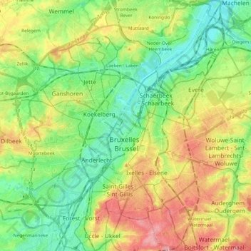
Name: Brussels topographic map, elevation, terrain.
Location: Brussels, Brussels-Capital, Belgium (50.79641 4.31400 50.91390 4.43707)
Average elevation: 53 m
Minimum elevation: 9 m
Maximum elevation: 121 m
Other topographic maps
Click on a map to view its topography, its elevation and its terrain.
Auderghem - Oudergem
Auderghem - Oudergem, Brussels-Capital, 1160, Belgium
Average elevation: 91 m