
Thank you for supporting this site ❤️
Make a donation
Make a donation
Central topographic map
Click on the map to display elevation.
Thank you for supporting this site ❤️
Make a donation
Make a donation
About this map
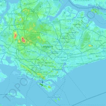
Name: Central topographic map, elevation, terrain.
Location: Central, Singapore (1.20725 103.79265 1.44541 103.91849)
Average elevation: 13 m
Minimum elevation: -6 m
Maximum elevation: 166 m
Thank you for supporting this site ❤️
Make a donation
Make a donation
Other topographic maps
Click on a map to view its topography, its elevation and its terrain.
Thank you for supporting this site ❤️
Make a donation
Make a donation
Bukit Batok Nature Park
The peak of Bukit Batok Hill stands at an elevation of 107m above sea level. Temperature ranges from 23°C to 30°C during "Winter/Wet" season. During Summer, temperature ranges from 24°C to 33°C.
Average elevation: 45 m