
Mohyliv topographic map
Interactive map
Click on the map to display elevation.
About this map
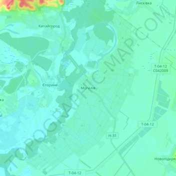
Name: Mohyliv topographic map, elevation, terrain.
Average elevation: 67 m
Minimum elevation: 58 m
Maximum elevation: 129 m
Other topographic maps
Click on a map to view its topography, its elevation and its terrain.
Shevchenkivskyi district
Ukraine > Dnipropetrovsk Oblast
Note: In May 2015 President of Ukraine Petro Poroshenko signed a bill into law that started a six-month period for the removal of communist monuments and the mandatory renaming of settlements with a name related to Communism. Hence Topograph in Dnipro was renamed in order to comply with these decommunization…
Average elevation: 99 m
Dnipro
Ukraine > Dnipropetrovsk Oblast
Under the Köppen–Geiger climate classification system, Dnipro has a humid continental climate (Dfa/Dfb). Snowfall is more common in the hills than at the city's lower elevations. The city has four distinct seasons: a cold, snowy winter; a hot summer; and two relatively wet transition periods. However,…
Average elevation: 90 m
Shevchenkivskyi district
Ukraine > Dnipropetrovsk Oblast
Note: In May 2015 President of Ukraine Petro Poroshenko signed a bill into law that started a six-month period for the removal of communist monuments and the mandatory renaming of settlements with a name related to Communism. Hence Topograph in Dnipro was renamed in order to comply with these decommunization…
Average elevation: 99 m