
Montalegre topographic map
Interactive map
Click on the map to display elevation.
About this map
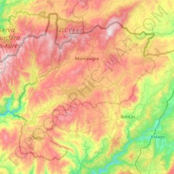
Name: Montalegre topographic map, elevation, terrain.
Location: Montalegre, Vila Real, North, Portugal (41.58690 -8.11947 41.92710 -7.57953)
Average elevation: 834 m
Minimum elevation: 247 m
Maximum elevation: 1,523 m
At an elevation of 1,000 m (3,281 ft) above sea level, Montalegre has a cool Mediterranean climate (Köppen: Csb). There is a short dry season in summer, but overall plenty of precipitation annually. The average annual temperature is around 10 °C (50 °F) and the average annual rainfall is 1,434 mm (56.5 in). The driest month is July, with 23 mm (0.91 in). Most precipitation falls in December, with an average of 252 mm (9.9 in).