
Make a donation
Yaremche topographic map
Click on the map to display elevation.
Make a donation
Yaremche
Yaremche (Ukrainian: Яре́мче, romanized: Jaremče, Polish: Jaremcze or Jaremcza) is a city in Nadvirna Raion, Ivano-Frankivsk Oblast (province) of west Ukraine. The city is located at the altitude of around 580 metres (1,900 ft) above mean sea level. Yaremche hosts the administration of Yaremche urban hromada, one of the hromadas of Ukraine. Population: 7,907 (2022 est.).
Make a donation
About this map
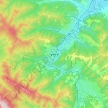
Name: Yaremche topographic map, elevation, terrain.
Average elevation: 819 m
Minimum elevation: 420 m
Maximum elevation: 1,659 m
Make a donation
Other topographic maps
Click on a map to view its topography, its elevation and its terrain.
Make a donation
Make a donation
Make a donation
Bukovel
Ukraine > Ivano-Frankivsk Oblast > Polianytsia
Bukovel (Ukrainian: Буковель) is the largest ski resort in Eastern Europe situated in Ukraine, in Nadvirna Raion, Ivano-Frankivsk Oblast (province) of western Ukraine. A part of it is in state property. The resort is located almost on the ridge-lines of the Carpathian Mountains at elevation of 900 m…
Average elevation: 1,009 m
Bukovel
Ukraine > Ivano-Frankivsk Oblast > Polianytsia
Bukovel is the largest ski resort in Eastern Europe situated in Ukraine, in Nadvirna Raion, Ivano-Frankivsk Oblast (province) of western Ukraine. A part of it is in state property. The resort is located almost on the ridge-lines of the Carpathian Mountains at elevation of 900 m (3,000 ft) above the sea level…
Average elevation: 1,009 m
Make a donation