
Laurel topographic map
Interactive map
Click on the map to display elevation.
About this map
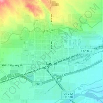
Name: Laurel topographic map, elevation, terrain.
Location: Laurel, Yellowstone County, Montana, United States (45.66104 -108.79056 45.68737 -108.72821)
Average elevation: 1,019 m
Minimum elevation: 992 m
Maximum elevation: 1,093 m
Other topographic maps
Click on a map to view its topography, its elevation and its terrain.
Billings
United States > Montana > Yellowstone County
Billings, Yellowstone County, Montana, United States
Average elevation: 1,023 m
Huntley
United States > Montana > Yellowstone County
Huntley, Yellowstone County, Montana, United States
Average elevation: 924 m
Yegen
United States > Montana > Yellowstone County
Yegen, Yellowstone County, Montana, United States
Average elevation: 981 m