
Gulf Shores topographic map
Interactive map
Click on the map to display elevation.
About this map
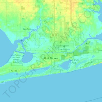
Name: Gulf Shores topographic map, elevation, terrain.
Location: Gulf Shores, Baldwin County, Alabama, 36542, United States (30.23023 -87.80176 30.33396 -87.62320)
Average elevation: 5 m
Minimum elevation: -2 m
Maximum elevation: 19 m
Jack Edwards National Airport is located in Gulf Shores and offers services from Gulf Air Center, Salt Air Aviation Center and Platium Air Center. The airport is located in town, two miles from the beach. Their FBO Gulf Air Center will provide a rental vehicle while they take care of fueling and storing aircraft. There is 48-hour and long term parking available. The longest paved runway extends 6,962 feet. The facility is at an elevation of 17 feet. They offer outside tiedown as well as hangar space for aircraft. They can provide space by the night, week or month.
Other topographic maps
Click on a map to view its topography, its elevation and its terrain.
Foley
United States > Alabama > Baldwin County
Foley, Baldwin County, Alabama, United States
Average elevation: 20 m
Fairhope
United States > Alabama > Baldwin County > Fairhope
Fairhope, Baldwin County, Alabama, United States
Average elevation: 35 m
Daphne
United States > Alabama > Baldwin County
Daphne, Baldwin County, Alabama, 36526, United States
Average elevation: 25 m
Robertsdale
United States > Alabama > Baldwin County
Robertsdale, Baldwin County, Alabama, United States
Average elevation: 41 m
Douglasville
United States > Alabama > Baldwin County > Bay Minette
Douglasville, Bay Minette, Baldwin County, Alabama, 36507, United States
Average elevation: 75 m
Montrose
United States > Alabama > Baldwin County > Fairhope
Montrose, Fairhope, Baldwin County, Alabama, 36559, United States
Average elevation: 17 m
Orange Beach
United States > Alabama > Baldwin County
Orange Beach, Baldwin County, Alabama, United States
Average elevation: 5 m
Point Clear
United States > Alabama > Baldwin County
Point Clear, Baldwin County, Alabama, 36564, United States
Average elevation: 10 m
Ono Island
United States > Alabama > Baldwin County
Ono Island, Baldwin County, Alabama, United States
Average elevation: 9 m
Stockton
United States > Alabama > Baldwin County
Stockton, Baldwin County, Alabama, United States
Average elevation: 20 m
Park City
United States > Alabama > Baldwin County > Daphne
Park City, Daphne, Baldwin County, Alabama, 36526, United States
Average elevation: 17 m
Bay Minette
United States > Alabama > Baldwin County
Bay Minette, Baldwin County, Alabama, 36507, United States
Average elevation: 72 m
Gulf Shores
United States > Alabama > Baldwin County
Gulf Shores, Baldwin County, Alabama, 36542, United States
Average elevation: 4 m
Loxley
United States > Alabama > Baldwin County
Loxley, Baldwin County, Alabama, 36551, United States
Average elevation: 46 m
Perdido Bay
United States > Alabama > Baldwin County
Perdido Bay, Baldwin County, Alabama, United States
Average elevation: 0 m
Fairhope
United States > Alabama > Baldwin County
Fairhope, Baldwin County, Alabama, 36533, United States
Average elevation: 17 m
Perdido River
United States > Alabama > Baldwin County
Perdido River, Baldwin County, Alabama, 35507, United States
Average elevation: 43 m
Spanish Fort
United States > Alabama > Baldwin County
Spanish Fort, Baldwin County, Alabama, United States
Average elevation: 21 m
Summerdale
United States > Alabama > Baldwin County > Summerdale
Summerdale, Baldwin County, Alabama, United States
Average elevation: 34 m
Bay Minette
United States > Alabama > Baldwin County > Bay Minette
Bay Minette, Baldwin County, Alabama, 36507, United States
Average elevation: 72 m
Fairhope
United States > Alabama > Baldwin County > Fairhope
Fairhope, Baldwin County, Alabama, United States
Average elevation: 35 m
Caswell
United States > Alabama > Baldwin County > Orange Beach > Caswell
Caswell, Orange Beach, Baldwin County, Alabama, 36561, United States
Average elevation: 3 m
Lillian
United States > Alabama > Baldwin County
Lillian, Baldwin County, Alabama, 46549, United States
Average elevation: 8 m