
Make a donation
Скидель topographic map
Click on the map to display elevation.
Make a donation
About this map
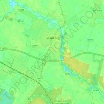
Name: Скидель topographic map, elevation, terrain.
Location: Скидель, Гродненский район, Гродненская область, Беларусь (53.55278 24.18810 53.60573 24.27829)
Average elevation: 115 m
Minimum elevation: 106 m
Maximum elevation: 123 m
Make a donation
Other topographic maps
Click on a map to view its topography, its elevation and its terrain.
Опорный пункт Гродненской крепости
Беларусь > Гродненская область > Гродненский район > Коптёвский сельский Совет
Average elevation: 171 m
Форт № 4
Беларусь > Гродненская область > Гродненский район > Подлабенский сельский Совет
Average elevation: 153 m
Форт 5
Беларусь > Гродненская область > Гродненский район > Коптёвский сельский Совет
Average elevation: 180 m
озеро Дубки
Беларусь > Гродненская область > Гродненский район > Одельский сельский Совет
Average elevation: 193 m
Make a donation
Месторасположение Форта 10 Гродненской крепости
Беларусь > Гродненская область > Гродненский район > Путришковский сельский Совет
Average elevation: 154 m
Школьная
Беларусь > Гродненская область > Гродненский район > Поречский сельский Совет
Average elevation: 127 m