
Leadville topographic map
Interactive map
Click on the map to display elevation.
About this map
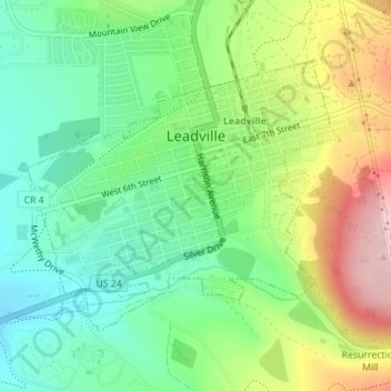
Name: Leadville topographic map, elevation, terrain.
Location: Leadville, Lake County, Colorado, 80461, United States (39.23730 -106.30754 39.25598 -106.27958)
Average elevation: 3,106 m
Minimum elevation: 3,023 m
Maximum elevation: 3,247 m
The City of Leadville is a statutory city that is the county seat, the most populous community, and the only incorporated municipality in Lake County, Colorado, United States. The city population was 2,602 at the 2010 census and an estimated 2,762 in 2018. It is situated at an elevation of 10,152 feet (3,094 m). Leadville is the highest incorporated city in the United States and it is surrounded by two of the tallest 14,000 foot peaks in the state.
Other topographic maps
Click on a map to view its topography, its elevation and its terrain.
Leadville
United States > Colorado > Lake County
Leadville, Lake County, Colorado, 80461, United States
Average elevation: 3,106 m
Leadville North
United States > Colorado > Lake County > Leadville
Leadville North, Leadville, Lake County, Colorado, United States
Average elevation: 3,040 m
Crystal Lakes
United States > Colorado > Lake County
Crystal Lakes, Lake County, Colorado, United States
Average elevation: 2,899 m
Lake Creek
United States > Colorado > Lake County
Lake Creek, Lake County, Colorado, 81251, United States
Average elevation: 3,293 m
Hagerman Lake
United States > Colorado > Lake County
Hagerman Lake, Lake County, Colorado, United States
Average elevation: 3,484 m
Lake Isabelle
United States > Colorado > Lake County
Lake Isabelle, Lake County, Colorado, United States
Average elevation: 3,600 m
Mount Elbert
United States > Colorado > Lake County
Mount Elbert, Lake County, Colorado, United States
Average elevation: 3,958 m
Mount Sherman
United States > Colorado > Lake County
Mount Sherman, Lake County, Colorado, United States
Average elevation: 3,989 m
Mount Massive
United States > Colorado > Lake County
Mount Massive, Lake County, Colorado, United States
Average elevation: 4,021 m