
La Rivière topographic map
Interactive map
Click on the map to display elevation.
About this map
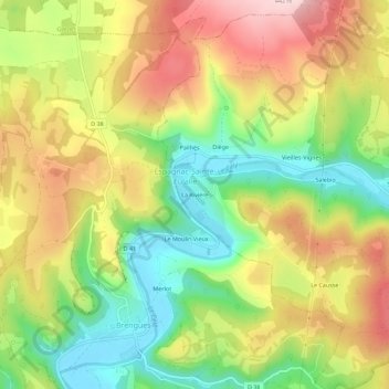
Name: La Rivière topographic map, elevation, terrain.
Average elevation: 290 m
Minimum elevation: 158 m
Maximum elevation: 434 m
Other topographic maps
Click on a map to view its topography, its elevation and its terrain.
Pailhès
France > Occitanie > Lot > Espagnac-Sainte-Eulalie
Pailhès, Espagnac-Sainte-Eulalie, Figeac, Lot, Occitanie, France métropolitaine, 46320, France
Average elevation: 303 m