
Kataula topographic map
Interactive map
Click on the map to display elevation.
About this map
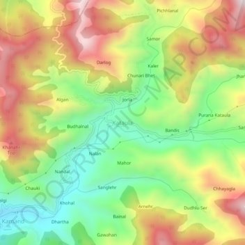
Name: Kataula topographic map, elevation, terrain.
Average elevation: 1,374 m
Minimum elevation: 1,027 m
Maximum elevation: 1,783 m
Other topographic maps
Click on a map to view its topography, its elevation and its terrain.
Salgi
India > Himachal Pradesh > Mandi > Kamand
Salgi, Kamand, Mandi, Mandi District, Himachal Pradesh, 175075, India
Average elevation: 1,269 m
Bari
India > Himachal Pradesh > Mandi > Mandi
Bari, Mandi, Mandi District, Himachal Pradesh, 175001, India
Average elevation: 1,068 m
Rewalsar
India > Himachal Pradesh > Mandi
Rewalsar, Mandi, Himachal Pradesh, 175023, India
Average elevation: 1,283 m
Beas River
India > Himachal Pradesh > Mandi > Mandi > Bari
Beas River, Bari, Mandi, Himachal Pradesh, 175001, India
Average elevation: 948 m
Bagi
India > Himachal Pradesh > Mandi > Bagi
Bagi, Mandi, Himachal Pradesh, India
Average elevation: 1,981 m