
Argenton topographic map
Interactive map
Click on the map to display elevation.
About this map
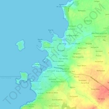
Name: Argenton topographic map, elevation, terrain.
Average elevation: 15 m
Minimum elevation: -1 m
Maximum elevation: 56 m
Other topographic maps
Click on a map to view its topography, its elevation and its terrain.
Parc Kerriou
France > Bretagne > Finistère > Argenton
Parc Kerriou, Argenton, Landunvez, Brest, Finistère, Bretagne, France métropolitaine, 29840, France
Average elevation: 19 m
Poul Treas
France > Bretagne > Finistère > Argenton
Poul Treas, Argenton, Landunvez, Brest, Finistère, Bretagne, France métropolitaine, 29840, France
Average elevation: 15 m