
Lake Murray Dam topographic map
Interactive map
Click on the map to display elevation.
About this map
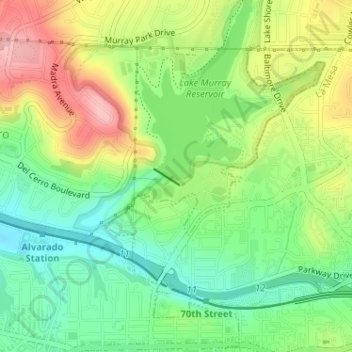
Name: Lake Murray Dam topographic map, elevation, terrain.
Average elevation: 165 m
Minimum elevation: 103 m
Maximum elevation: 252 m
Other topographic maps
Click on a map to view its topography, its elevation and its terrain.
Otay Mesa
United States > California > San Diego
Otay Mesa, San Diego, San Diego County, California, 92179, United States
Average elevation: 167 m
Southcrest Community Park
United States > California > San Diego
Southcrest Community Park, South Crest, San Diego, San Diego County, California, United States
Average elevation: 22 m
North Bay Terraces
United States > California > San Diego > North Bay Terraces
North Bay Terraces, San Diego, San Diego County, California, 92114, United States
Average elevation: 107 m