
Ingquza Hill Local Municipality topographic map
Interactive map
Click on the map to display elevation.
About this map
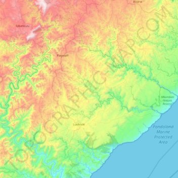
Name: Ingquza Hill Local Municipality topographic map, elevation, terrain.
Average elevation: 526 m
Minimum elevation: -1 m
Maximum elevation: 1,660 m
Other topographic maps
Click on a map to view its topography, its elevation and its terrain.
Lusikisiki
South Africa > Eastern Cape > O.R. Tambo District Municipality > Ingquza Hill Local Municipality
Lusikisiki, Ingquza Hill Local Municipality, O.R. Tambo District Municipality, Eastern Cape, South Africa
Average elevation: 563 m