
Chesterville topographic map
Interactive map
Click on the map to display elevation.
About this map
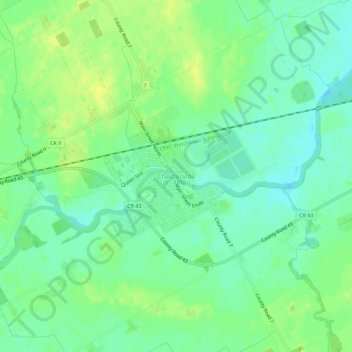
Name: Chesterville topographic map, elevation, terrain.
Average elevation: 74 m
Minimum elevation: 65 m
Maximum elevation: 84 m
Other topographic maps
Click on a map to view its topography, its elevation and its terrain.
Ormond
Canada > Ontario > Stormont, Dundas and Glengarry Counties > North Dundas
Ormond, North Dundas, Stormont, Dundas and Glengarry Counties, Eastern Ontario, Ontario, Canada
Average elevation: 77 m
Timmins Drain
Canada > Ontario > Stormont, Dundas and Glengarry Counties > North Dundas
Timmins Drain, North Dundas, Stormont, Dundas and Glengarry Counties, Eastern Ontario, Ontario, Canada
Average elevation: 72 m
Winchester
Canada > Ontario > Stormont, Dundas and Glengarry Counties > North Dundas
Winchester, North Dundas, Stormont, Dundas and Glengarry Counties, Eastern Ontario, Ontario, K0C 2K0, Canada
Average elevation: 76 m
Hallville
Canada > Ontario > Stormont, Dundas and Glengarry Counties > North Dundas
Hallville, North Dundas, Stormont, Dundas and Glengarry Counties, Eastern Ontario, Ontario, Canada
Average elevation: 91 m