
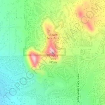
Pinnacle Peak topographic map
Interactive map
Click on the map to display elevation.
About this map
Name: Pinnacle Peak topographic map, elevation, terrain.
Average elevation: 753 m
Minimum elevation: 658 m
Maximum elevation: 915 m
Pinnacle Peak is a granite summit located in Scottsdale, Arizona. The peak rises to an elevation of 3,169 feet (966 m). It is located within the 150-acre (61 ha) Pinnacle Peak Park, operated by the City of Scottsdale Park District. Part of the Sonoran Desert, the park is home to a variety of native desert flora and fauna. Hikers utilize a 1.75 mile trail to explore the area, though rock climbing skills are needed to reach the summit.
Other topographic maps
Click on a map to view its topography, its elevation and its terrain.
Tom's Thumb
United States > Arizona > Maricopa County > Scottsdale
Tom's Thumb, Scottsdale, Maricopa County, Arizona, United States
Average elevation: 981 m
Butte Peak
United States > Arizona > Maricopa County > Scottsdale
Butte Peak, Scottsdale, Maricopa County, Arizona, United States
Average elevation: 1,279 m
Brown's Mountain
United States > Arizona > Maricopa County > Scottsdale
Brown's Mountain, Scottsdale, Maricopa County, Arizona, 85262, United States
Average elevation: 827 m
Pinnacle Peak Park
United States > Arizona > Maricopa County > Scottsdale
Pinnacle Peak Park, 26802, North 102nd Way, Scottsdale, Maricopa County, Arizona, United States
Average elevation: 762 m