
Avant topographic map
Interactive map
Click on the map to display elevation.
About this map
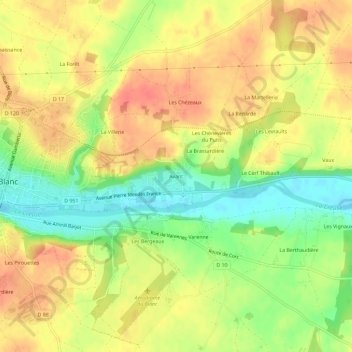
Name: Avant topographic map, elevation, terrain.
Average elevation: 107 m
Minimum elevation: 75 m
Maximum elevation: 130 m
Other topographic maps
Click on a map to view its topography, its elevation and its terrain.
L'Ipaudière
France > Centre-Val de Loire > Indre > Le Blanc
L'Ipaudière, Le Blanc, Indre, Centre-Val de Loire, France métropolitaine, 36300, France
Average elevation: 111 m
Les Zéros
France > Centre-Val de Loire > Indre > Le Blanc
Les Zéros, Le Blanc, Indre, Centre-Val de Loire, France métropolitaine, 36300, France
Average elevation: 106 m
La Renaissance
France > Centre-Val de Loire > Indre > Le Blanc
La Renaissance, Le Blanc, Indre, Centre-Val de Loire, France métropolitaine, 36300, France
Average elevation: 109 m
Ville-Haute
France > Centre-Val de Loire > Indre > Le Blanc
Ville-Haute, Le Blanc, Indre, Centre-Val de Loire, France métropolitaine, 36300, France
Average elevation: 111 m