
Suffolk topographic map
Interactive map
Click on the map to display elevation.
About this map
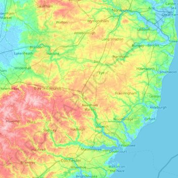
Name: Suffolk topographic map, elevation, terrain.
Location: Suffolk, England, United Kingdom (51.93176 0.33997 52.55022 1.76891)
Average elevation: 35 m
Minimum elevation: -4 m
Maximum elevation: 130 m
The west of the county lies on more resistant Cretaceous chalk. This chalk is responsible for a sweeping tract of largely downland landscapes that stretches from Dorset in the south west to Dover in the south east and north through East Anglia to the Yorkshire Wolds. The chalk is less easily eroded so forms the only significant hills in the county. The highest point in the county is Great Wood Hill, with an elevation of 128 metres (420 ft). It is the highest point of the Newmarket Ridge and is near the villages of Rede and Chedburgh.
Other topographic maps
Click on a map to view its topography, its elevation and its terrain.
London
United Kingdom > England > London
London, Greater London, England, SW1A 2DX, United Kingdom
Average elevation: 42 m
London
London, Greater London, England, United Kingdom
Average elevation: 66 m
Sheffield
Sheffield, South Yorkshire, England, United Kingdom
Average elevation: 168 m
Cambridgeshire
Cambridgeshire, Cambridgeshire and Peterborough, England, United Kingdom
Average elevation: 32 m
Bristol
United Kingdom > England > City of Bristol
Bristol, City of Bristol, West of England, England, United Kingdom
Average elevation: 55 m
Liverpool
Liverpool, Liverpool City Region, England, United Kingdom
Average elevation: 26 m
Nottingham
United Kingdom > England > Nottinghamshire
Nottingham, England, United Kingdom
Average elevation: 56 m
South East England
South East England, England, United Kingdom
Average elevation: 69 m
Wirral
Wirral, Liverpool City Region, England, United Kingdom
Average elevation: 21 m
Bath
United Kingdom > England > Bath and North East Somerset
Bath, Bath and North East Somerset, West of England, England, United Kingdom
Average elevation: 100 m
Bradford
Bradford, West Yorkshire, England, United Kingdom
Average elevation: 175 m
Guildford
United Kingdom > England > Surrey
Guildford, Surrey, England, United Kingdom
Average elevation: 74 m
South Pool
United Kingdom > England > Devon > South Hams
South Pool, South Hams, Devon, England, United Kingdom
Average elevation: 38 m
Stibb Cross
United Kingdom > England > Devon > Torridge District
Stibb Cross, Langtree, Torridge District, Devon, England, EX38 8HZ, United Kingdom
Average elevation: 157 m
Brent Eleigh
United Kingdom > England > Suffolk > Babergh
Brent Eleigh, Babergh, Suffolk, England, United Kingdom
Average elevation: 64 m
Westridge Green
United Kingdom > England > West Berkshire > Aldworth
Westridge Green, Aldworth, West Berkshire, England, RG8 9RF, United Kingdom
Average elevation: 145 m
North Norfolk
United Kingdom > England > Norfolk
North Norfolk, Norfolk, England, United Kingdom
Average elevation: 26 m
Huddersfield
United Kingdom > England > Kirklees
Huddersfield, Kirklees, West Yorkshire, England, HD1 2AA, United Kingdom
Average elevation: 145 m
North East England
North East England, England, United Kingdom
Average elevation: 165 m
Richmond Park
United Kingdom > England > London
Richmond Park, London Borough of Richmond upon Thames, London, Greater London, England, United Kingdom
Average elevation: 26 m
Somerset
Somerset, South West England, England, United Kingdom
Average elevation: 87 m
Pontefract
United Kingdom > England > Wakefield
Pontefract, Wakefield, West Yorkshire, England, WF8 1AX, United Kingdom
Average elevation: 41 m
Manchester
Manchester, Greater Manchester, England, United Kingdom
Average elevation: 66 m
Oxford
United Kingdom > England > Oxfordshire
Oxford, Oxfordshire, England, United Kingdom
Average elevation: 81 m
St Albans
United Kingdom > England > Hertfordshire > St Albans
St Albans, Hertfordshire, East of England, England, United Kingdom
Average elevation: 100 m
Newcastle upon Tyne
Newcastle upon Tyne, North of Tyne, England, United Kingdom
Average elevation: 57 m
Birmingham
Birmingham, West Midlands Combined Authority, England, United Kingdom
Average elevation: 138 m
Lake District National Park
Lake District National Park, England, United Kingdom
Average elevation: 206 m
Worksop
United Kingdom > England > Nottinghamshire > Bassetlaw
Worksop, Bassetlaw, Nottinghamshire, England, S80 1JB, United Kingdom
Average elevation: 56 m
Boston
United Kingdom > England > Lincolnshire
Boston, Lincolnshire, England, United Kingdom
Average elevation: 3 m
Huckworthy
United Kingdom > England > Devon > West Devon > Walkhampton
Huckworthy, Sampford Spiney, Walkhampton, West Devon, Devon, England, PL20 6LP, United Kingdom
Average elevation: 196 m
Lincolnshire
Lincolnshire, East Midlands, England, United Kingdom
Average elevation: 28 m
City of London
United Kingdom > England > City of London > City of London
City of London, England, EC2V 5AE, United Kingdom
Average elevation: 42 m
City of Bristol
City of Bristol, West of England, England, United Kingdom
Average elevation: 80 m
Greater London
Greater London, England, United Kingdom
Average elevation: 66 m
Grantham
United Kingdom > England > Lincolnshire > South Kesteven
Grantham, South Kesteven, Lincolnshire, England, United Kingdom
Average elevation: 85 m
Winchester
United Kingdom > England > Hampshire
Winchester, Hampshire, England, United Kingdom
Average elevation: 73 m
Coventry
Coventry, West Midlands Combined Authority, England, United Kingdom
Average elevation: 99 m