Geolocate

Dolomites topographic map

Interactive map

Click on the map to display elevation.

About this map

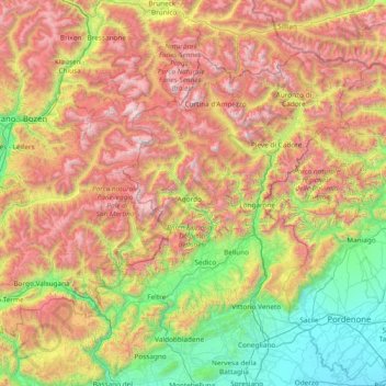
Name: Dolomites topographic map, elevation, terrain.

Location: Dolomites, Veneto, Italy (45.77312 11.38871 46.81604 12.54756)

Average elevation: 1,216 m

Minimum elevation: 3 m

Maximum elevation: 3,242 m

Other topographic maps

Click on a map to view its topography, its elevation and its terrain.

Arabba

Italy > Veneto > Belluno

Average elevation: 1,938 m

Calmasino

Italy > Veneto > Verona > Bardolino

Average elevation: 134 m

Monte Schiara

Italy > Veneto > Belluno > Sedico

The Schiara (Italian: Monte Schiara) is a mountain in the southern Dolomites of Veneto in northern Italy. It is located just north of the town of Belluno, approximately 50 miles north of Venice. Monte Schiara has an elevation of 2,565 metres.

Average elevation: 1,852 m

Salionze

Italy > Veneto > Verona > Valeggio sul Mincio

Average elevation: 96 m

Peron

Italy > Veneto > Belluno > Sedico

Average elevation: 579 m

Tasi

Italy > Veneto > Verona > Bosco Chiesanuova

Average elevation: 1,023 m

Bosco

Italy > Veneto > Province of Padua > Rubano

Average elevation: 17 m

Mormontea

Italy > Veneto > Verona > Illasi

Average elevation: 162 m

Pale di San Martino

Italy > Veneto > Belluno

Average elevation: 1,585 m

Vallesella

Italy > Veneto > Belluno > Grea

Average elevation: 928 m

Monte Cengio

Italy > Veneto > Vicenza > Cogollo del Cengio

Monte Cengio is a mountain in the Asiago plateau, within the Vicentine Alps, in Veneto, northeastern Italy. It has an elevation of 1,354 metres and is located on the southwestern edge of the plateau, in the territory of Cogollo del Cengio.

Average elevation: 935 m

Varda

Italy > Veneto > Belluno > Arabba

Average elevation: 1,859 m

Pale di San Martino

Italy > Veneto > Belluno

Average elevation: 1,585 m

Mas

Italy > Veneto > Belluno > Sedico

Average elevation: 448 m

Mestre

Italy > Veneto > Venezia > Venice

Average elevation: 4 m

Albisano

Italy > Veneto > Verona

Average elevation: 253 m

Sottoguda

Italy > Veneto > Belluno

Average elevation: 1,745 m

Cinque Torri

Italy > Veneto > Belluno > Cortina d'Ampezzo

Average elevation: 2,071 m

Monte Pizzoc

Italy > Veneto > Province of Treviso > Fregona

Pizzoc is a mountain of the Veneto, Italy. It has an elevation of 1,565 metres.

Average elevation: 1,240 m

Bibano

Italy > Veneto > Province of Treviso

Average elevation: 37 m

Cadin di Sotto

Italy > Veneto > Belluno > Cortina d'Ampezzo

Average elevation: 1,473 m

Bosco

Italy > Veneto > Province of Padua > Rubano

Average elevation: 17 m

Arabba

Italy > Veneto > Belluno

Average elevation: 1,938 m

Burano

Italy > Veneto > Venezia > Venice > Burano

Average elevation: 0 m

Giralba

Italy > Veneto > Belluno > Auronzo di Cadore

Average elevation: 1,806 m

Fosse di Sopra

Italy > Veneto > Vicenza > Enego

Average elevation: 680 m

Vich

Italy > Veneto > Belluno > Voltago Agordino

Average elevation: 1,328 m

Corbane

Italy > Veneto > Verona > Bosco Chiesanuova

Average elevation: 1,089 m

Tormeno

Italy > Veneto > Vicenza

Average elevation: 54 m

Borago

Italy > Veneto > Verona > Assenza

Average elevation: 362 m

Belvedere

Italy > Veneto > Vicenza

Average elevation: 68 m

Peron

Italy > Veneto > Belluno > Sedico

Average elevation: 579 m

Passo di Riva

Italy > Veneto > Vicenza > Dueville

Average elevation: 61 m

Sandon

Italy > Veneto > Venezia

Average elevation: 4 m

Campolongo

Italy > Veneto > Belluno

Average elevation: 1,219 m

Chiamulera

Italy > Veneto > Belluno > Cortina d'Ampezzo

Average elevation: 1,503 m

San Giorgio

Italy > Veneto > Verona > Bosco Chiesanuova

Average elevation: 1,514 m

Motta

Italy > Veneto > Vicenza

Average elevation: 52 m

Sandon

Italy > Veneto > Venezia

Average elevation: 4 m

Malcanton

Italy > Veneto > Province of Treviso > Asolo > Pagnano

Average elevation: 161 m

San Benedetto

Italy > Veneto > Vicenza

Average elevation: 55 m

San Zeno

Italy > Veneto > Vicenza > Cassola

Average elevation: 107 m

Campedello

Italy > Veneto > Vicenza > Vicenza

Average elevation: 46 m

Ospedaletto

Italy > Veneto > Vicenza > Vicenza

Average elevation: 37 m

Azzano

Italy > Veneto > Verona > Castel d'Azzano

Average elevation: 47 m

Salton

Italy > Veneto > Province of Treviso > Tarzo

Average elevation: 295 m

Ca' di David

Italy > Veneto > Verona > Verona

Average elevation: 50 m

Staffalo

Italy > Veneto > Verona > Castelnuovo del Garda

Average elevation: 86 m

Castion

Italy > Veneto > Belluno > Belluno

Average elevation: 425 m

Pozzolo

Italy > Veneto > Vicenza

Average elevation: 196 m

Quinzano

Italy > Veneto > Verona > Verona

Average elevation: 151 m

Campo

Italy > Veneto > Verona > Marniga

Average elevation: 382 m

Primolano

Italy > Veneto > Vicenza

Average elevation: 582 m

Perarolo

Italy > Veneto > Province of Padua > Vigonza

Average elevation: 9 m

Capriccio

Italy > Veneto > Province of Padua > Vigonza

Average elevation: 9 m

Lago di Corlo

Italy > Veneto > Belluno > Rocca d'Arsiè

Average elevation: 592 m

Tre Cime di Lavaredo - Drei Zinnen

Italy > Veneto > Belluno > Auronzo di Cadore

Until 1919 the peaks formed part of the border between Italy and Austria-Hungary. Now they lie on the border between the Italian provinces of South Tyrol and Belluno and still are a part of the linguistic boundary between German-speaking and Italian-speaking majorities. The Cima Grande has an elevation of…

Average elevation: 2,242 m

Brioni

Italy > Veneto > Treviso > San Vito di Altivole

Average elevation: 83 m

Tre Cime di Lavaredo - Drei Zinnen

Italy > Veneto > Belluno > Auronzo di Cadore

Until 1919 the peaks formed part of the border between Italy and Austria-Hungary. Now they lie on the border between the Italian provinces of South Tyrol and Belluno and still are a part of the linguistic boundary between German-speaking and Italian-speaking majorities. The Cima Grande has an elevation of…

Average elevation: 2,242 m

Sas de Stria

Italy > Veneto > Belluno > Cortina d'Ampezzo

Sass de Stria is a mountain of the Veneto, Italy. It has an elevation of 2,477 meters. During the First World War, the mountain and surrounding area was the scene of fighting between Italy and Austria-Hungary.

Average elevation: 2,138 m

Pescul

Italy > Veneto > Belluno > Santa Fosca

Average elevation: 1,703 m

Bibione

Italy > Veneto > Venezia

Average elevation: 0 m

Misurina

Italy > Veneto > Belluno > Auronzo di Cadore

Average elevation: 1,954 m

Tre Cime di Lavaredo - Drei Zinnen

Italy > Veneto > Belluno > Auronzo di Cadore

Until 1919 the peaks formed part of the border between Italy and Austria-Hungary. Now they lie on the border between the Italian provinces of South Tyrol and Belluno and still are a part of the linguistic boundary between German-speaking and Italian-speaking majorities. The Cima Grande has an elevation of…

Average elevation: 2,242 m

Lido

Italy > Veneto > Venezia > Venice

Average elevation: 0 m

Sant'Erasmo

Italy > Veneto > Venezia > Venice > Sant'Erasmo

Average elevation: 0 m

Ossati

Italy > Veneto > Vicenza > Laghi

Average elevation: 757 m

Murano

Italy > Veneto > Venezia > Venice

Average elevation: 1 m

Lido

Italy > Veneto > Venezia > Venice

Average elevation: 0 m

Lago di Santa Croce

Italy > Veneto > Belluno > Farra d'Alpago

Average elevation: 542 m

Verona

Italy > Veneto > Verona > Verona

Average elevation: 189 m

Mestre

Italy > Veneto > Venezia

Average elevation: 5 m

Cortina d'Ampezzo

Italy > Veneto > Belluno > Cortina d'Ampezzo > Cortina d'Ampezzo

Among the surrounding mountains are Tofane to the west, Pomagagnon to the north, Cristallo to the northeast, Faloria and Sorapiss to the east, and Becco di Mezzodì, Croda da Lago and Cinque Torri to the south. Monte Antelao (Nantelou in Ladin) is at 3264 m the highest mountain in the Ampezzo Dolomites and the…

Average elevation: 1,649 m

Lido di Jesolo

Italy > Veneto > Venezia > Jesolo > Lido di Jesolo

Average elevation: 0 m

Lago di Fimon

Italy > Veneto > Vicenza > Lapio > Casare

Average elevation: 121 m

Garda

Italy > Veneto > Verona > Garda > Garda

Average elevation: 155 m

Murano

Italy > Veneto > Venice

Average elevation: 0 m

Torrente Malisia

Italy > Veneto > Belluno > Forno di Zoldo

Average elevation: 1,208 m

Sarego

Italy > Veneto > Vicenza > Schio > Monte Magrè > Sarego

Average elevation: 456 m

La Ca'

Italy > Veneto > Verona > San Zeno di Montagna > La Ca'

Average elevation: 626 m

Pecol

Italy > Veneto > Belluno > Pecol

Average elevation: 1,631 m

Pieve di Cadore

Italy > Veneto > Belluno > Pieve di Cadore > Pieve di Cadore

Average elevation: 1,116 m

Clama

Italy > Veneto > Vicenza > Asiago > Clama

Average elevation: 1,055 m

Favaro Veneto

Italy > Veneto > Venezia > Venice > Favaro Veneto

Average elevation: 3 m

Calgari

Italy > Veneto > Vicenza > Arsiero > Calgari

Average elevation: 735 m