
Watauga County topographic map
Interactive map
Click on the map to display elevation.
About this map
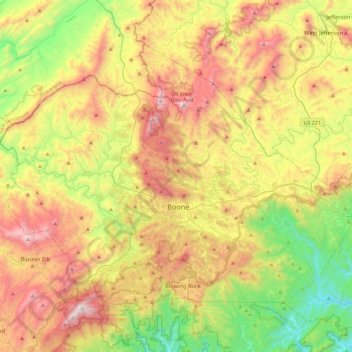
Name: Watauga County topographic map, elevation, terrain.
Location: Watauga County, North Carolina, United States of America (36.11148 -81.91808 36.39129 -81.45591)
Average elevation: 984 m
Minimum elevation: 377 m
Maximum elevation: 1,777 m
As with most of North Carolina's High Country, the climate of Watauga County is that of a Humid continental climate characterized by considerably cooler and more drastic weather than other parts of the state. Dramatic and unexpected changes in the weather are not uncommon in the county, particularly when it comes to precipitation. This is partly due to the elevation of the county, and partly due to orographic lifting, which causes precipitation to fall more readily in Watauga County than in lowland areas to the east. Summers can be very warm with temperatures commonly in the 80s and on a rare occasion in the 90s. Snow usually starts in November, and there can be snow falls in April, although this is not usual. Windy conditions tend to be amplified across the county due to the rugged terrain and high elevation. Many people have noted that the winters of Watauga County tend to resemble those of the northern United States instead of the South.
Other topographic maps
Click on a map to view its topography, its elevation and its terrain.
Blowing Rock
United States of America > North Carolina > Blowing Rock
Blowing Rock, Watauga County, North Carolina, 28605, United States of America
Average elevation: 1,032 m
Outer Banks
United States of America > North Carolina
Outer Banks, Dare County, North Carolina, 27982, United States of America
Average elevation: 0 m
Pinehurst
United States of America > North Carolina > Pinehurst
Pinehurst, Moore County, North Carolina, 28374, United States of America
Average elevation: 138 m
Northwest
United States of America > North Carolina > Northwest
Northwest, Brunswick County, North Carolina, United States of America
Average elevation: 16 m