
Raigad topographic map
Interactive map
Click on the map to display elevation.
About this map
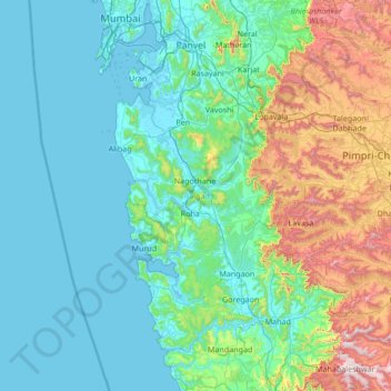
Name: Raigad topographic map, elevation, terrain.
Location: Raigad, Maharashtra, India (17.84917 72.81173 19.13490 73.67531)
Average elevation: 241 m
Minimum elevation: -2 m
Maximum elevation: 1,434 m
Other topographic maps
Click on a map to view its topography, its elevation and its terrain.
Banganga River
India > Maharashtra > Niphad > Ojhar
Banganga River, Ojhar, Niphad, Nashik, Maharashtra, 422206, India
Average elevation: 584 m
Dharavi
India > Maharashtra > Mumbai
Dharavi, Zone 2, Mumbai, Mumbai City, Maharashtra, India
Average elevation: 6 m
Chinchwad
India > Maharashtra > Chinchwad
Chinchwad, Kolhapur, Maharashtra, 416112, India
Average elevation: 548 m
Karjat
India > Maharashtra > Karjat
Karjat, Kulāba, Raigad, Maharashtra, 410201, India
Average elevation: 109 m