
Surrey topographic map
Interactive map
Click on the map to display elevation.
About this map
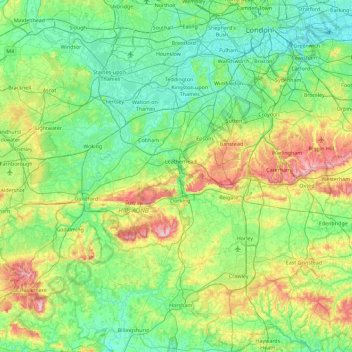
Name: Surrey topographic map, elevation, terrain.
Average elevation: 69 m
Minimum elevation: -1 m
Maximum elevation: 289 m
Other topographic maps
Click on a map to view its topography, its elevation and its terrain.
London
United Kingdom > England > London
London, Greater London, England, SW1A 2DX, United Kingdom
Average elevation: 42 m
London
United Kingdom > England > London
London Borough of Sutton, London, Greater London, England, United Kingdom
Average elevation: 71 m
Biggin Hill
United Kingdom > England > London > Biggin Hill
Biggin Hill, London, Greater London, England, TN16 3BE, United Kingdom
Average elevation: 171 m