
Alsace topographic map
Interactive map
Click on the map to display elevation.
Alsace
Alsace has an oceanic climate at low altitude and a continental climate at high altitude. There is fairly low precipitation because the Vosges protect it from the west. The city of Colmar has a sunny microclimate; it is the second driest city in France, with an annual precipitation of around 700 mm (28 in), making it ideal for vin d'Alsace (Alsatian wine).
About this map
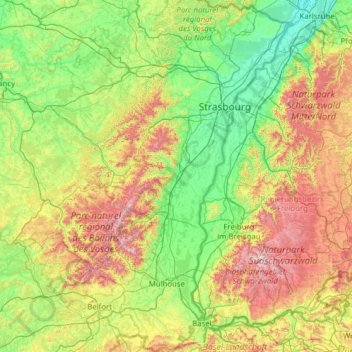
Name: Alsace topographic map, elevation, terrain.
Location: Alsace, Metropolitan France, France (47.42034 6.84132 49.07779 8.23285)
Average elevation: 414 m
Minimum elevation: 100 m
Maximum elevation: 1,471 m
Other topographic maps
Click on a map to view its topography, its elevation and its terrain.
Le Moulin de Dore
France > Nouvelle-Aquitaine > Charente-Maritime > Barzan-Plage > Chez Pilou
Average elevation: 9 m
Roche de Solutré
France > Bourgogne-Franche-Comté > Saône-et-Loire > Solutré-Pouilly
Average elevation: 371 m
Île de Vassivière
France > Nouvelle-Aquitaine > Haute-Vienne > Beaumont-du-Lac
Average elevation: 664 m
Le Colombier
France > Nouvelle-Aquitaine > Corrèze > Lamazière-Basse > Le Colombier
Average elevation: 516 m
Le Balestier
France > New Aquitaine > Coux et Bigaroque-Mouzens > Le Balestier
Average elevation: 171 m
Luchon-Superbagnères
France > Occitania > Saint-Aventin > Luchon-Superbagnères
Average elevation: 1,331 m