
Ostrand der Arendseer Hochfläche topographic map
Interactive map
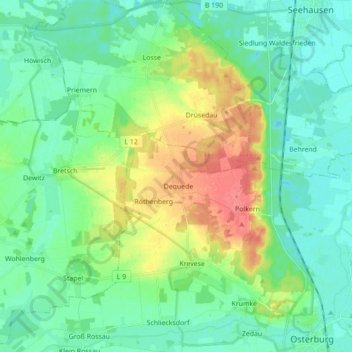
Click on the map to display elevation.
About this map
Name: Ostrand der Arendseer Hochfläche topographic map, elevation, terrain.
Average elevation: 35 m
Minimum elevation: 18 m
Maximum elevation: 74 m
Other topographic maps
Click on a map to view its topography, its elevation and its terrain.
Krevese
Deutschland > Sachsen-Anhalt > Osterburg (Altmark) > Krevese
Krevese, Osterburg (Altmark), Stendal, Sachsen-Anhalt, Deutschland
Average elevation: 47 m
Dequede
Deutschland > Sachsen-Anhalt > Osterburg (Altmark) > Krevese
Dequede, Krevese, Osterburg (Altmark), Stendal, Sachsen-Anhalt, Deutschland
Average elevation: 59 m