
Kennesaw topographic map
Interactive map
Click on the map to display elevation.
About this map
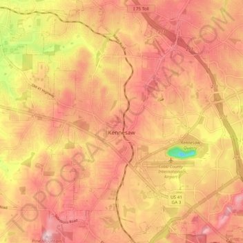
Name: Kennesaw topographic map, elevation, terrain.
Location: Kennesaw, Cobb County, Georgia, United States (33.98696 -84.65002 34.06690 -84.58092)
Average elevation: 317 m
Minimum elevation: 167 m
Maximum elevation: 393 m
Kennesaw is located in northwestern Cobb County, bordered by the city of Acworth to the northwest. Kennesaw Mountain is located southeast of the city limits in the battlefield park. Its summit is the highest point in the Atlanta metro area, at an elevation of 1,808 feet (551 m) above sea level. The city was renamed for the mountain.
Other topographic maps
Click on a map to view its topography, its elevation and its terrain.
Marietta
United States > Georgia > Cobb County
Marietta, Cobb County, Georgia, United States
Average elevation: 323 m