
Moab topographic map
Interactive map
Click on the map to display elevation.
About this map
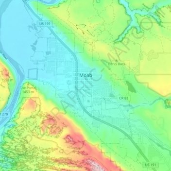
Name: Moab topographic map, elevation, terrain.
Location: Moab, Grand County, Utah, 84532, United States (38.53621 -109.57965 38.60318 -109.51532)
Average elevation: 1,357 m
Minimum elevation: 1,200 m
Maximum elevation: 1,746 m
Moab is just south of the Colorado River, at an elevation of 4,025 feet (1,227 m) on the Colorado Plateau. It is 18 miles (29 km) west of the Utah/Colorado state line. Via U.S. Route 191, it is 31 miles (50 km) south of Interstate 70 at Crescent Junction, and it is 54 miles (87 km) north of Monticello. Via Utah State Route 128 it is 46 miles (74 km) southwest of Cisco. The entrance to Arches National Park is 4 miles (6 km) north of Moab on US 191. Hurrah Pass is located on the trail between Moab and Chicken Corners.
Other topographic maps
Click on a map to view its topography, its elevation and its terrain.
Westwater
United States > Utah > Grand County
Westwater, Grand County, Utah, United States
Average elevation: 1,349 m
Cisco
United States > Utah > Grand County
Cisco, Grand County, Utah, 84515, United States
Average elevation: 1,334 m
Rectory
United States > Utah > Grand County
Rectory, Grand County, Utah, United States
Average elevation: 1,527 m
Delicate Arch
United States > Utah > Grand County
Delicate Arch, Delicate Arch Trail, Grand County, Utah, United States
Average elevation: 1,409 m
Thompson Springs
United States > Utah > Grand County
Thompson Springs, Grand County, Utah, 84540, United States
Average elevation: 1,583 m
Arches National Park
United States > Utah > Grand County
Arches National Park, Grand County, Utah, United States
Average elevation: 1,476 m
Colorado River
United States > Utah > Grand County > Moab
Colorado River, Moab, Grand County, Utah, United States
Average elevation: 1,668 m
Castle Valley
United States > Utah > Grand County
Castle Valley, Grand County, Utah, United States
Average elevation: 1,610 m
Cottonwood Point
United States > Utah > Grand County
Cottonwood Point, Grand County, Utah, United States
Average elevation: 2,346 m
La Sal Mountains Viewpoint
United States > Utah > Grand County
La Sal Mountains Viewpoint, Main Park Road, Grand County, Utah, 84532-2134, United States
Average elevation: 1,347 m