
Païta topographic map
Interactive map
Click on the map to display elevation.
About this map
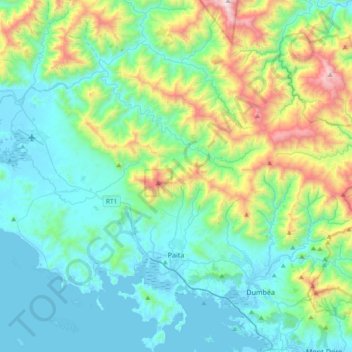
Name: Païta topographic map, elevation, terrain.
Location: Païta, South Province, New Caledonia, France (-22.22665 166.11174 -21.87992 166.47285)
Average elevation: 342 m
Minimum elevation: -2 m
Maximum elevation: 1,587 m
Other topographic maps
Click on a map to view its topography, its elevation and its terrain.