
Corrèze topographic map
Interactive map
Click on the map to display elevation.
About this map
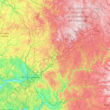
Name: Corrèze topographic map, elevation, terrain.
Location: Corrèze, New Aquitaine, Metropolitan France, France (44.92049 1.22696 45.76528 2.52866)
Average elevation: 481 m
Minimum elevation: 77 m
Maximum elevation: 975 m
The department transitions between the Aquitaine and the Massif Central, the Corrèze department sees its elevation gradually rise from the basin of Brive to the Plateau de Millevaches, watershed of the Atlantic facade. This relief explains the wide variety of climates of Corrèze.
Other topographic maps
Click on a map to view its topography, its elevation and its terrain.