
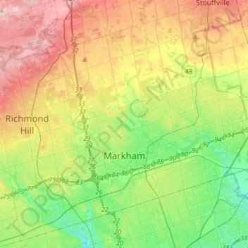
Markham topographic map
Interactive map
Click on the map to display elevation.
About this map
Name: Markham topographic map, elevation, terrain.
Location: Markham, York Region, Golden Horseshoe, Ontario, Canada (43.79804 -79.42873 43.96251 -79.17024)
Average elevation: 216 m
Minimum elevation: 135 m
Maximum elevation: 333 m
Markham's average altitude is at 200 m (660 ft) and in general consists of gently rolling hills. The city is intersected by two rivers; the Don River and Rouge River, as well as their tributaries. To the north is the Oak Ridges Moraine, which further elevates the elevation towards the north.