
Post Falls topographic map
Interactive map
Click on the map to display elevation.
About this map
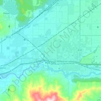
Name: Post Falls topographic map, elevation, terrain.
Location: Post Falls, Kootenai County, Idaho, 83854, United States (47.69255 -117.04179 47.75945 -116.85641)
Average elevation: 710 m
Minimum elevation: 619 m
Maximum elevation: 1,295 m
Post Falls is located on the Rathdrum Prairie, along the Washington–Idaho border. It is bounded by Coeur d’Alene to the east, Stateline and the state of Washington to the west, and the Spokane River to the south. Post Falls is 20 miles (32 km) east of Spokane and approximately 100 miles (160 km) south of the Canada–United States border. The elevation of the city is 2,182 feet (665 m) above sea level.
Other topographic maps
Click on a map to view its topography, its elevation and its terrain.
Coeur d'Alene
United States > Idaho > Kootenai County
Coeur d'Alene, Kootenai County, Idaho, 83815, United States
Average elevation: 719 m
Hauser
United States > Idaho > Kootenai County
Hauser, Kootenai County, Idaho, United States
Average elevation: 712 m
Bayview
United States > Idaho > Kootenai County
Bayview, Kootenai County, Idaho, United States
Average elevation: 733 m
Farragut State Park
United States > Idaho > Kootenai County > Bayview
Farragut State Park, Bayview, Kootenai County, Idaho, United States
Average elevation: 723 m
Fernan Saddle
United States > Idaho > Kootenai County
Fernan Saddle, Kootenai County, Idaho, United States
Average elevation: 1,201 m
Lake Coeur d'Alene
United States > Idaho > Kootenai County > Harrison
Lake Coeur d'Alene, Harrison, Kootenai County, Idaho, United States
Average elevation: 827 m
Fernan Lake
United States > Idaho > Kootenai County > Coeur d'Alene
Fernan Lake, Coeur d'Alene, Kootenai County, Idaho, United States
Average elevation: 743 m
Hayden
United States > Idaho > Kootenai County
Hayden, Kootenai County, Idaho, United States
Average elevation: 709 m
Cataldo
United States > Idaho > Kootenai County
Cataldo, Kootenai County, Idaho, 83839, United States
Average elevation: 732 m
Athol
United States > Idaho > Kootenai County
Athol, Kootenai County, Idaho, United States
Average elevation: 733 m
Bellgrove
United States > Idaho > Kootenai County
Bellgrove, Kootenai County, Idaho, United States
Average elevation: 802 m
Silver Sands Beach
United States > Idaho > Kootenai County
Silver Sands Beach, Kootenai County, Idaho, United States
Average elevation: 766 m
Hauser Lake
United States > Idaho > Kootenai County > Hauser
Hauser Lake, Hauser, Kootenai County, Idaho, United States
Average elevation: 696 m
Hayden
United States > Idaho > Kootenai County
Hayden, Kootenai County, Idaho, 83835, United States
Average elevation: 717 m
Cherry Hill
United States > Idaho > Kootenai County > Coeur d'Alene
Cherry Hill, Coeur d'Alene, Kootenai County, Idaho, 83815, United States
Average elevation: 708 m
Dalton Gardens
United States > Idaho > Kootenai County
Dalton Gardens, Kootenai County, Idaho, United States
Average elevation: 697 m
Rathdrum
United States > Idaho > Kootenai County
Rathdrum, Kootenai County, Idaho, United States
Average elevation: 701 m
Spirit Lake
United States > Idaho > Kootenai County
Spirit Lake, Kootenai County, Idaho, 83869, United States
Average elevation: 780 m
Harrison
United States > Idaho > Kootenai County
Harrison, Kootenai County, Idaho, United States
Average elevation: 745 m
Worley
United States > Idaho > Kootenai County
Worley, Kootenai County, Idaho, United States
Average elevation: 830 m