
Manitoba topographic map
Interactive map
Click on the map to display elevation.
About this map
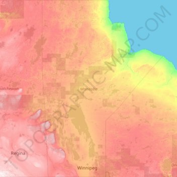
Name: Manitoba topographic map, elevation, terrain.
Location: Manitoba, Canada (48.99886 -102.00758 59.99951 -88.98653)
Average elevation: 293 m
Minimum elevation: -1 m
Maximum elevation: 1,001 m
Other topographic maps
Click on a map to view its topography, its elevation and its terrain.
Clarendon Parish
Clarendon Parish, Charlotte County, New Brunswick, Canada
Average elevation: 160 m
Ile-à-la-Crosse
Canada > Saskatchewan > Division No. 18
Ile-à-la-Crosse, Division No. 18, Saskatchewan, S0M 1C0, Canada
Average elevation: 423 m
Saint Quentin Parish
Saint Quentin Parish, Restigouche County, New Brunswick, E8A 1H5, Canada
Average elevation: 341 m
Inuvik
Canada > Northwest Territories
Inuvik, Northwest Territories, X0E 0T0, Canada
Average elevation: 29 m
Blainville
Canada > Quebec > Thérèse-De Blainville
Blainville, Thérèse-De Blainville, Laurentides, Quebec, Canada
Average elevation: 66 m
Parksville
Canada > British Columbia > Regional District of Nanaimo
Parksville, Regional District of Nanaimo, British Columbia, Canada
Average elevation: 38 m
Area D (Sproat Lake)
Canada > British Columbia > Alberni-Clayoquot Regional District
Area D (Sproat Lake), Alberni-Clayoquot Regional District, British Columbia, V9Y 8Y5, Canada
Average elevation: 615 m
Framboise
Canada > Nova Scotia > Municipality of the County of Richmond
Framboise, Municipality of the County of Richmond, Richmond County, Nova Scotia, Canada
Average elevation: 23 m
Vancouver Island
Vancouver Island, British Columbia, Canada
Average elevation: 411 m
Barrier Islands
Canada > Ontario > Kenora District > Unorganized Kenora District
Barrier Islands, Unorganized Kenora District, Kenora District, Northwestern Ontario, Ontario, Canada
Average elevation: 345 m
McMurrich
Canada > Ontario > Parry Sound District > McMurrich/Monteith Township
McMurrich, McMurrich/Monteith Township, Parry Sound District, Central Ontario, Ontario, Canada
Average elevation: 337 m
Axe Lake
Canada > Ontario > Kenora District > Unorganized Kenora District
Axe Lake, Unorganized Kenora District, Kenora District, Northwestern Ontario, Ontario, Canada
Average elevation: 369 m
Amherst
Canada > Quebec > Les Laurentides
Amherst, Les Laurentides, Laurentides, Quebec, J0T 2L0, Canada
Average elevation: 286 m
Division No. 18
Canada > Manitoba > Division No. 18
Division No. 18, Manitoba, Canada
Average elevation: 249 m
Scarborough Bluffs
Scarborough Bluffs, Toronto, Golden Horseshoe, Ontario, M1M 1C7, Canada
Average elevation: 120 m
Langford
Canada > British Columbia > Capital Regional District > Langford
Langford, Capital Regional District, British Columbia, Canada
Average elevation: 116 m
Mount Brewster
Canada > Alberta > Improvement District No. 9
Mount Brewster, Improvement District No. 9, Alberta, Canada
Average elevation: 2,305 m
Markham
Canada > Ontario > York Region > Markham
Markham, York Region, Golden Horseshoe, Ontario, Canada
Average elevation: 216 m
Central Saanich
Canada > British Columbia > Central Saanich
Central Saanich, Capital Regional District, British Columbia, Canada
Average elevation: 58 m
Kashechewan
Canada > Ontario > Kashechewan
Kashechewan, Kenora District, Northwestern Ontario, Ontario, P0L 1S0, Canada
Average elevation: 6 m
Georgetown
Canada > Ontario > Georgetown
Georgetown, Halton Hills, Halton Region, Golden Horseshoe, Ontario, L7G 4T3, Canada
Average elevation: 255 m
Negeek Lake
Canada > Ontario > Brudenell, Lyndoch and Raglan
Negeek Lake, Brudenell, Lyndoch and Raglan, Renfrew County, Eastern Ontario, Ontario, Canada
Average elevation: 306 m
Pointe-à-la-Croix
Canada > Quebec > Pointe-à-la-Croix
Pointe-à-la-Croix, Avignon, Gaspésie–Îles-de-la-Madeleine, Quebec, G0C 1L0, Canada
Average elevation: 6 m
North Grenville
Canada > Ontario > North Grenville
North Grenville, Leeds and Grenville Counties, Eastern Ontario, Ontario, Canada
Average elevation: 98 m
Fort McMurray
Canada > Alberta > Fort McMurray
Fort McMurray, Wood Buffalo, Alberta, Canada
Average elevation: 345 m
Abbotsford
Canada > British Columbia > Abbotsford
Abbotsford, British Columbia, Canada
Average elevation: 99 m
Rainy Lake
Canada > Ontario > Unorganized Rainy River
Rainy Lake, Unorganized Rainy River, Rainy River District, Ontario, Canada
Average elevation: 356 m
Carpenter Lake
Canada > British Columbia > Area A (Upper Bridge River Valley)
Carpenter Lake, Area A (Upper Bridge River Valley), Squamish-Lillooet Regional District, British Columbia, V0K 1P0, Canada
Average elevation: 1,592 m
Loch Lomond
Loch Lomond, Municipality of the County of Richmond, Richmond County, Nova Scotia, Canada
Average elevation: 81 m
Pee Pee Island
Canada > Newfoundland and Labrador
Pee Pee Island, Newfoundland, Newfoundland and Labrador, Canada
Average elevation: 16 m
Ivy Lea
Canada > Ontario > Leeds and the Thousand Islands > Ivy Lea
Ivy Lea, Leeds and the Thousand Islands, Leeds and Grenville Counties, Eastern Ontario, Ontario, K0E 1L0, Canada
Average elevation: 87 m
Jasper National Park
Jasper National Park, Bighorn Highway, Cadomin, Yellowhead County, Alberta, T0E 1E0, Canada
Average elevation: 1,782 m