
Ga East topographic map
Interactive map
Click on the map to display elevation.
About this map
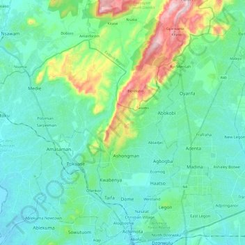
Name: Ga East topographic map, elevation, terrain.
Location: Ga East, Greater Accra Region, GH-GE328-3680, Ghana (5.61131 -0.29929 5.84637 -0.12550)
Average elevation: 98 m
Minimum elevation: 14 m
Maximum elevation: 435 m
Other topographic maps
Click on a map to view its topography, its elevation and its terrain.
La
Ghana > Greater Accra Region > La-Dade-Kotopon Municipal District > Accra > La
Average elevation: 16 m