
Southern Leyte topographic map
Interactive map
Click on the map to display elevation.
Southern Leyte
Along with other mountain forms in the province, Mount Nacolod in Hinunangan town has the highest peak with an elevation of 948 metres (3,110 ft) above sea level. Young volcanic rocks are discovered in the terrain areas, which cover the top of the southern mountain ranges of Mount Cabalian in the Pacific Area and Mount Nelangcapan in Panaon Area.
About this map
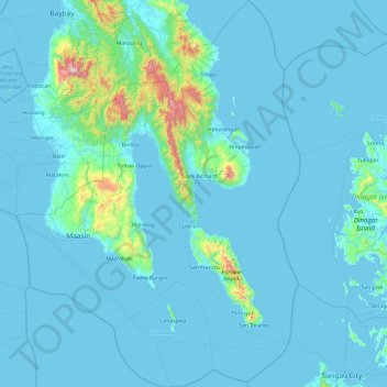
Name: Southern Leyte topographic map, elevation, terrain.
Location: Southern Leyte, Eastern Visayas, Philippines (9.76192 124.68340 10.70833 125.38922)
Average elevation: 66 m
Minimum elevation: -1 m
Maximum elevation: 1,113 m