
Koudiet N'Aït Arif topographic map
Interactive map
Click on the map to display elevation.
About this map
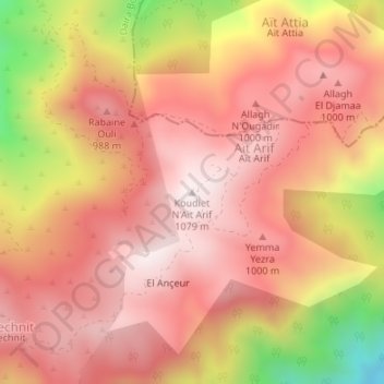
Name: Koudiet N'Aït Arif topographic map, elevation, terrain.
Location: Koudiet N'Aït Arif, Ouled Slama, Daïra Bougara, Blida, Algérie (36.49985 3.14830 36.49995 3.14840)
Average elevation: 840 m
Minimum elevation: 364 m
Maximum elevation: 1,066 m