
Jerome topographic map
Interactive map
Click on the map to display elevation.
Jerome
Jerome is about 100 miles (160 km) north of Phoenix and 45 miles (72 km) southwest of Flagstaff along Arizona State Route 89A between Sedona to the east and Prescott to the west. The town is in Arizona's Black Hills, which trend north–south. The town lies within the Prescott National Forest at an elevation of more than 5,000 feet (1,500 m). Woodchute Wilderness is about 3 miles (5 km) west of Jerome, and Mingus Mountain, at 7,726 feet (2,355 m) above sea level, is about 4 miles (6 km) south of town. Jerome State Historic Park is in the town itself. Bitter Creek, a tributary of the Verde River, flows intermittently through Jerome. East of Jerome at the base of the hills are the Verde Valley and the communities of Clarkdale and Cottonwood, site of the nearest airport.
About this map
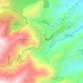
Name: Jerome topographic map, elevation, terrain.
Location: Jerome, Yavapai County, Arizona, 86331, United States (34.73958 -112.11939 34.75395 -112.09424)
Average elevation: 1,574 m
Minimum elevation: 1,291 m
Maximum elevation: 1,930 m