
Killarney Municipal District topographic map
Interactive map
Click on the map to display elevation.
About this map
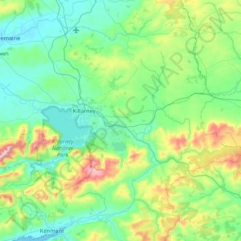
Name: Killarney Municipal District topographic map, elevation, terrain.
Location: Killarney Municipal District, County Kerry, Munster, Ireland (51.93822 -9.70578 52.15162 -9.11875)
Average elevation: 191 m
Minimum elevation: -1 m
Maximum elevation: 951 m
Other topographic maps
Click on a map to view its topography, its elevation and its terrain.
Blanchardstown
Blanchardstown was a predominantly rural area, with a small village, in western County Dublin, alongside the neighbouring district of Castleknock. Both areas shared a common history until well into the 19th century, when their development diverged. In A Topographical Dictionary of Ireland, published in 1837,…
Average elevation: 61 m