
Sandy Hook topographic map
Interactive map
Click on the map to display elevation.
About this map
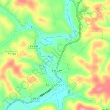
Name: Sandy Hook topographic map, elevation, terrain.
Location: Sandy Hook, Elliott County, Kentucky, United States (38.07983 -83.13701 38.10848 -83.11043)
Average elevation: 261 m
Minimum elevation: 207 m
Maximum elevation: 327 m
Other topographic maps
Click on a map to view its topography, its elevation and its terrain.
Culver
United States > Kentucky > Elliott County
Culver, Elliott County, Kentucky, United States
Average elevation: 271 m
Stark
United States > Kentucky > Elliott County
Stark, Elliott County, Kentucky, United States
Average elevation: 285 m
Ibex
United States > Kentucky > Elliott County
Ibex, Elliott County, Kentucky, United States
Average elevation: 249 m
Newfoundland
United States > Kentucky > Elliott County
Newfoundland, Elliott County, Kentucky, 41171, United States
Average elevation: 259 m
Isonville
United States > Kentucky > Elliott County
Isonville, Elliott County, Kentucky, 41149, United States
Average elevation: 275 m