
Salyersville topographic map
Interactive map
Click on the map to display elevation.
About this map
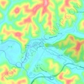
Name: Salyersville topographic map, elevation, terrain.
Location: Salyersville, Magoffin County, Kentucky, United States (37.73400 -83.08013 37.76860 -83.03349)
Average elevation: 298 m
Minimum elevation: 252 m
Maximum elevation: 380 m
Other topographic maps
Click on a map to view its topography, its elevation and its terrain.
Carver
United States > Kentucky > Magoffin County
Carver, Magoffin County, Kentucky, United States
Average elevation: 347 m
Burning Fork
United States > Kentucky > Magoffin County > Burning Fork
Burning Fork, Magoffin County, Kentucky, 41465, United States
Average elevation: 312 m