
Thank you for supporting this site ❤️
Make a donation
Make a donation
Davis Mountains State Park topographic map
Click on the map to display elevation.
Thank you for supporting this site ❤️
Make a donation
Make a donation
About this map
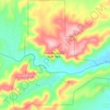
Name: Davis Mountains State Park topographic map, elevation, terrain.
Average elevation: 1,603 m
Minimum elevation: 1,489 m
Maximum elevation: 1,735 m
Thank you for supporting this site ❤️
Make a donation
Make a donation
Other topographic maps
Click on a map to view its topography, its elevation and its terrain.
Sleeping Lion Mountain
United States > Texas > Jeff Davis County > Fort Davis
Average elevation: 1,512 m