
Make a donation
Kolkata topographic map
Click on the map to display elevation.
Make a donation
Kolkata
Spread roughly north–south along the east bank of the Hooghly River, Kolkata sits within the lower Ganges Delta of eastern India approximately 75 km (47 mi) west of the international border with Bangladesh; the city's elevation is 1.5–9 m (5–30 ft). Much of the city was originally a wetland that was reclaimed over the decades to accommodate a burgeoning population. The remaining undeveloped areas, known as the East Kolkata Wetlands, were designated a "wetland of international importance" by the Ramsar Convention (1975). As with most of the Indo-Gangetic Plain, the soil and water are predominantly alluvial in origin. Kolkata is located over the "Bengal basin", a pericratonic tertiary basin. Bengal basin comprises three structural units: shelf or platform in the west; central hinge or shelf/slope break; and deep basinal part in the east and southeast. Kolkata is located atop the western part of the hinge zone which is about 25 km (16 mi) wide at a depth of about 45,000 m (148,000 ft) below the surface. The shelf and hinge zones have many faults, among them some are active. Total thickness of sediment below Kolkata is nearly 7,500 m (24,600 ft) above the crystalline basement; of these the top 350–450 m (1,150–1,480 ft) is Quaternary, followed by 4,500–5,500 m (14,760–18,040 ft) of Tertiary sediments, 500–700 m (1,640–2,300 ft) trap wash of Cretaceous trap and 600–800 m (1,970–2,620 ft) Permian-Carboniferous Gondwana rocks. The quaternary sediments consist of clay, silt and several grades of sand and gravel. These sediments are sandwiched between two clay beds: the lower one at a depth of 250–650 m (820–2,130 ft); the upper one 10–40 m (30–130 ft) in thickness. According to the Bureau of Indian Standards, on a scale ranging from I to V in order of increasing susceptibility to earthquakes, the city lies inside seismic zone III.
Make a donation
About this map
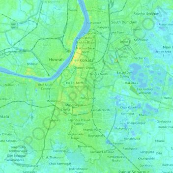
Name: Kolkata topographic map, elevation, terrain.
Location: Kolkata, West Bengal, India (22.45203 88.23363 22.61883 88.46108)
Average elevation: 5 m
Minimum elevation: -3 m
Maximum elevation: 23 m
Make a donation
Other topographic maps
Click on a map to view its topography, its elevation and its terrain.
Siliguri
India > West Bengal > Siliguri Subdivsion
Siliguri located at the foothills of the eastern Himalayas at a location of 26°43′N 88°26′E / 26.71°N 88.43°E / 26.71; 88.43. This city is spread over an area of 260 km2 within the Siliguri Corridor, also known as the Chicken's neck. The city is surrounded by dense forests towards north and…
Average elevation: 121 m
Jhargram
India > West Bengal > Jhargram
Jhargram is located at 22°27′N 86°59′E / 22.45°N 86.98°E / 22.45; 86.98. It has an average elevation of 81 metres (265 feet). The weather, like much of Bengal, is extremely humid and tropical. Temperatures can reach as high as 46 °C in the hot and dry months of May and June but can plummet to…
Average elevation: 79 m
Dinhata
India > West Bengal > Dinhata - I
Dinhata is located at 26°08′N 89°28′E / 26.13°N 89.47°E / 26.13; 89.47. It has an average elevation of 36 metres (118 feet).
Average elevation: 36 m
Shantipur
India > West Bengal > Santipur
Santipur is located at 23°15′N 88°26′E / 23.25°N 88.43°E / 23.25; 88.43. It has an average elevation of 15 metres (49 feet).
Average elevation: 11 m
Make a donation
Shantipur
India > West Bengal > Santipur
Santipur is located at 23°15′N 88°26′E / 23.25°N 88.43°E / 23.25; 88.43. It has an average elevation of 15 metres (49 feet).
Average elevation: 11 m
Kolkata
Spread roughly north–south along the east bank of the Hooghly River, Kolkata sits within the lower Ganges Delta of eastern India approximately 75 km (47 mi) west of the international border with Bangladesh; the city's elevation is 1.5–9 m (5–30 ft). Much of the city was originally a wetland that was…
Average elevation: 5 m
Siliguri
India > West Bengal > Siliguri Subdivsion
Siliguri is located at the foothills of the eastern Himalayas at a location of 26°43′N 88°26′E / 26.71°N 88.43°E / 26.71; 88.43. The city is spread over an area of 260 km2 (100 sq mi) within the Siliguri Corridor. The city is bordered by dense forests to the north and the Mahananda River flows…
Average elevation: 121 m
Make a donation
Krishnanagar
India > West Bengal > Krishnagar-I
Krishnanagar is located at 23°24′N 88°30′E / 23.4°N 88.5°E / 23.4; 88.5. The area of the municipality is around 16 km2. It is situated on the southern banks of the Jalangi River. It has an average elevation of 14 metres (46 ft). The Tropic of Cancer passes through the outskirts of…
Average elevation: 11 m
Ashoknagar Kalyangarh
India > West Bengal > Habra - II
Ashokenagar is located at 22°49′59″N 88°37′59″E / 22.833°N 88.633°E / 22.833; 88.633. It is situated in the World's largest delta, The Ganga-Brahmaputra Delta. The elevation of Ashokenagar Kalyangarh from sea-level is 8 meters. There are many forest, several lakes, some canals and vast…
Average elevation: 7 m
Make a donation
Make a donation
Konnagar
India > West Bengal > Serampur Uttarpara
Konnagar is located at 22°42′12″N 88°19′07″E / 22.7032°N 88.3185°E / 22.7032; 88.3185. It has an average elevation of 14 metres (45 feet). Konnagar is positioned between Rishra and Hind Motor on the Howrah-Bardhaman main line and Grand Trunk Road. It is located on the west bank of the…
Average elevation: 6 m
Make a donation
Bidhannagar
India > West Bengal > Bidhannagar
According to the Bidhannagar Municipal Corporation, the city area has a total area of 55.51 square kilometres (21.43 sq mi), with approx 30.51 square kilometres (11.78 sq mi) of it being land, and approx 25 square kilometres (9.7 sq mi), or 45.5% of the total, being covered by water. It has an average…
Average elevation: 5 m
Lava
India > West Bengal > Kalimpong - II
Lava (also known as Lava Bazar) is a town in the Kalimpong II CD block in the Kalimpong subdivision of the Kalimpong district in the Indian state of West Bengal. As it lies in the high altitude, so it is also visible from high altitude towns and villages of East Sikkim, high areas of Bhutan and also from…
Average elevation: 1,931 m
Make a donation
Brajalalchak
India > West Bengal > Haldia
Haldia is located at 22°02′N 88°04′E / 22.03°N 88.06°E / 22.03; 88.06. It has an average elevation of 8 metres (26 ft).
Average elevation: 5 m
Make a donation
Kurseong
India > West Bengal > Kurseong Subdivision
Located at an altitude of 1,482.55 metres (4,864.0 ft), Kurseong is 32 kilometres (20 mi) from Darjeeling and has a pleasant climate throughout the year.
Average elevation: 1,127 m
Make a donation
Memari
India > West Bengal > Memari - I
Memari is located at 23°12′N 88°07′E / 23.2°N 88.12°E / 23.2; 88.12. It has an average elevation of 25 metres (82 feet).
Average elevation: 21 m
Make a donation
Gopiballabhpur
India > West Bengal > Gopiballavpur-I
Gopiballavpur is located at 22°12′N 86°53′E / 22.20°N 86.89°E / 22.20; 86.89. It has an average elevation of 34 metres (114 feet).
Average elevation: 40 m
Make a donation
Diamond Harbour
India > West Bengal > Diamond Harbour - I
Diamond Harbour is located at 22°11′34″N 88°11′22″E / 22.1926886°N 88.1894879°E / 22.1926886; 88.1894879. It has an average elevation of 7 metres (23 ft).
Average elevation: 3 m
Make a donation
Dankuni
India > West Bengal > Chanditala - II
Located at an elevation of None meters (0 feet) above sea level, city's yearly temperature is 30.28 °C (86.5 °F) and it is 4.31% higher than India's averages. Dankuni typically receives about 150.21 millimeters (5.91 inches) of precipitation and has 150.54 rainy days (41.24% of the time) annually.
Average elevation: 6 m
Singur
India > West Bengal > Singur
Singur is located at 22°49′N 88°14′E / 22.81°N 88.23°E / 22.81; 88.23. It has an average elevation of 14 metres (45 ft), and is situated on the Ganges delta.
Average elevation: 9 m
Make a donation
Baruipur
India > West Bengal > Baruipur
Baruipur is located at 22°21′38″N 88°25′56″E / 22.3606792°N 88.4322502°E / 22.3606792; 88.4322502. It has an average elevation of 11 metres (36 ft).
Average elevation: 7 m
Panskura
India > West Bengal > Panskura
Panskura is located at 22°25′N 87°42′E / 22.42°N 87.7°E / 22.42; 87.7. It has an average elevation of 7 metres (26 feet). It is situated on the NH6 on the way from Kolkata to Kharagpur.
Average elevation: 7 m
Kharagpur
India > West Bengal > Kharagpur-I
Kharagpur is the fourth largest city of West Bengal in area after Kolkata, Durgapur and Asansol. It is also the fifth most populated city of West Bengal after Kolkata, Asansol, Siliguri, Durgapur - located at 22°19′49″N 87°19′25″E / 22.330239°N 87.323653°E / 22.330239; 87.323653, covering…
Average elevation: 39 m
Make a donation
Siliguri
India > West Bengal > Matigara block
Siliguri is located at the foothills of the eastern Himalayas at a location of 26°43′N 88°26′E / 26.71°N 88.43°E / 26.71; 88.43. The city is spread over an area of 260 km2 (100 sq mi) within the Siliguri Corridor, and has earned a moniker the Chicken's neck. The city is surrounded by dense…
Average elevation: 121 m
Dalkola
India > West Bengal > Karandighi
Dalkhola has an average elevation of 23 meters (75 feet) and is located at 25°51′N 87°51′E / 25.85°N 87.85°E / 25.85; 87.85.
Average elevation: 38 m
Make a donation
Siliguri
India > West Bengal > Siliguri Subdivsion
Siliguri is located at the foothills of the eastern Himalayas at a location of 26°43′N 88°26′E / 26.71°N 88.43°E / 26.71; 88.43. The city is spread over an area of 260 km2 (100 sq mi) within the Siliguri Corridor, and has earned a moniker the Chicken's neck. The city is surrounded by dense…
Average elevation: 121 m
Make a donation
Ilam Bazar
India > West Bengal > Illambazar
Ilambazar is located at 23°38′N 87°32′E / 23.63°N 87.53°E / 23.63; 87.53. It has an average elevation of 54 m (177 ft).
Average elevation: 58 m
Bidhannagar
India > West Bengal > Bidhannagar
According to the Bidhannagar Municipal Corporation, the city area has a total area of 55.51 square kilometres (21.43 sq mi), with approx 30.51 square kilometres (11.78 sq mi) of it being land, and approx 25 square kilometres (9.7 sq mi), or 45.5% of the total, being covered by water. It has an average…
Average elevation: 5 m
Make a donation
Berhampore
India > West Bengal > Berhampore
Berhampore is located at 24°06′N 88°15′E / 24.1°N 88.25°E / 24.1; 88.25. It has an average elevation of 18 metres (59 feet).
Average elevation: 20 m
Make a donation
Kharagpur
India > West Bengal > Kharagpur-I
Kharagpur is the fourth largest city of West Bengal in area after Kolkata, Durgapur and Asansol. It is also the fifth most populated city of West Bengal after Kolkata, Asansol, Siliguri, Durgapur - located at 22°19′49″N 87°19′25″E / 22.330239°N 87.323653°E / 22.330239; 87.323653, covering…
Average elevation: 39 m
Make a donation
Siliguri
India > West Bengal > Siliguri Subdivsion
Siliguri is located at the foothills of the eastern Himalayas at a location of 26°43′N 88°26′E / 26.71°N 88.43°E / 26.71; 88.43. The city is spread over an area of 260 km2 (100 sq mi) within the Siliguri Corridor, and has earned a moniker the Chicken's neck. The city is surrounded by dense…
Average elevation: 121 m
Berhampore
India > West Bengal > Berhampore
Berhampore is located at 24°06′N 88°15′E / 24.1°N 88.25°E / 24.1; 88.25. It has an average elevation of 18 metres (59 feet).
Average elevation: 20 m
Jaynagar Majilpur
India > West Bengal > Jaynagar - I
Jaynagar Majilpur is located at 22°10′31″N 88°25′12″E / 22.1751976°N 88.4200808°E / 22.1751976; 88.4200808. It has an average elevation of 8 metres (26 ft).
Average elevation: 5 m
Make a donation
Uluberia
India > West Bengal > Uluberia - I
Uluberia is located at 22°28′N 88°07′E / 22.47°N 88.11°E / 22.47; 88.11. It has an average elevation of 1 m (3.3 ft). It is situated on the banks of the river Hooghly. The main road passing through the heart of the city is Orissa trunk road and is also well connected by National Highway 16.…
Average elevation: 5 m
Digha
India > West Bengal > Digha
Digha is located at 21°38′18″N 87°30′35″E / 21.6384°N 87.5096°E / 21.6384; 87.5096. It has an average elevation of 6 metres (20 ft).
Average elevation: 4 m
Make a donation
Make a donation
Make a donation
Singur
India > West Bengal > Singur
Singur is located at 22°49′N 88°14′E / 22.81°N 88.23°E / 22.81; 88.23. It has an average elevation of 14 metres (45 ft), and is situated on the Ganges delta.
Average elevation: 9 m
Rishyap
India > West Bengal > Kalimpong - II
Rishyap is located at 27.03N & 88.18E. It has an average elevation of 2591 meters (8500 feet).
Average elevation: 1,789 m
Make a donation
Kharagpur
India > West Bengal > Kharagpur-I
Kharagpur is the fourth largest city of West Bengal in area after Kolkata, Durgapur and Asansol. It is also the fifth most populated city of West Bengal after Kolkata, Asansol, Siliguri, Durgapur - located at 22°19′49″N 87°19′25″E / 22.330239°N 87.323653°E / 22.330239; 87.323653, covering…
Average elevation: 39 m
Jaynagar Majilpur
India > West Bengal > Jaynagar - I
Jaynagar Majilpur is located at 22°10′31″N 88°25′12″E / 22.1751965°N 88.4200762°E / 22.1751965; 88.4200762. It has an average elevation of 8 metres (26 ft).
Average elevation: 5 m
Make a donation