
Jaoli topographic map
Interactive map
Click on the map to display elevation.
About this map
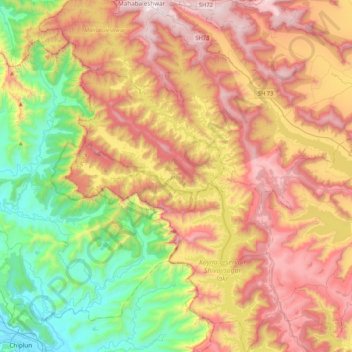
Name: Jaoli topographic map, elevation, terrain.
Location: Jaoli, Satara, Maharashtra, India (17.52465 73.56984 17.92725 73.98215)
Average elevation: 662 m
Minimum elevation: 2 m
Maximum elevation: 1,435 m
Other topographic maps
Click on a map to view its topography, its elevation and its terrain.
Medha
India > Maharashtra > Jaoli
Medha, Jaoli, Satara, Maharashtra, 415012, India
Average elevation: 758 m
Koyna reservoir Shivajisagar lake
India > Maharashtra > Jaoli > Vele
Koyna reservoir Shivajisagar lake, Vele, Jaoli, Satara District, Maharashtra, India
Average elevation: 644 m