
Pointe Noir topographic map
Interactive map
Click on the map to display elevation.
About this map
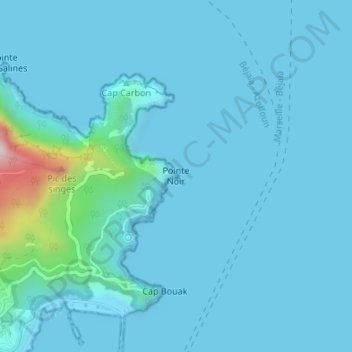
Name: Pointe Noir topographic map, elevation, terrain.
Location: Pointe Noir, Béjaïa, Daïra Béjaïa, Béjaïa, 06000, Algérie (36.75897 5.09722 36.77897 5.11722)
Average elevation: 43 m
Minimum elevation: -2 m
Maximum elevation: 554 m
Other topographic maps
Click on a map to view its topography, its elevation and its terrain.