
Thank you for supporting this site ❤️
Make a donation
Make a donation
Haren topographic map
Click on the map to display elevation.
Thank you for supporting this site ❤️
Make a donation
Make a donation
About this map
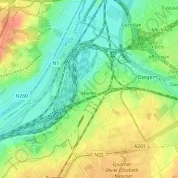
Name: Haren topographic map, elevation, terrain.
Location: Haren, Brussels, Brussels-Capital, Belgium (50.87213 4.39462 50.91167 4.43707)
Average elevation: 34 m
Minimum elevation: 8 m
Maximum elevation: 75 m
Thank you for supporting this site ❤️
Make a donation
Make a donation
Other topographic maps
Click on a map to view its topography, its elevation and its terrain.
Parc de Laeken - Park van Laken
Belgium > Brussels-Capital > Brussels > Laeken - Laken
Average elevation: 47 m