
Torngat Mountains National Park topographic map
Interactive map
Click on the map to display elevation.
About this map
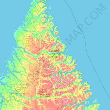
Name: Torngat Mountains National Park topographic map, elevation, terrain.
Average elevation: 214 m
Minimum elevation: -2 m
Maximum elevation: 1,547 m
Other topographic maps
Click on a map to view its topography, its elevation and its terrain.
Pee Pee Island
Canada > Newfoundland and Labrador
Pee Pee Island, Newfoundland, Newfoundland and Labrador, Canada
Average elevation: 16 m
Conne River
Canada > Newfoundland and Labrador
Conne River, Newfoundland and Labrador, Canada
Average elevation: 208 m
Whiteway
Canada > Newfoundland and Labrador > Whiteway
Whiteway, Newfoundland and Labrador, A0B 3L0, Canada
Average elevation: 48 m
Long Range Mountains
Canada > Newfoundland and Labrador
Long Range Mountains, Newfoundland and Labrador, Canada
Average elevation: 557 m
Cape Fox
Canada > Newfoundland and Labrador > Conche
Cape Fox, Martinique Drive, Conche, Newfoundland and Labrador, Canada
Average elevation: 6 m