
Dr Ruth Segomotsi Mompati District Municipality topographic map
Interactive map
Click on the map to display elevation.
About this map
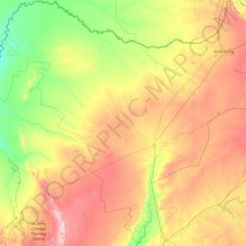
Name: Dr Ruth Segomotsi Mompati District Municipality topographic map, elevation, terrain.
Average elevation: 1,234 m
Minimum elevation: 976 m
Maximum elevation: 1,854 m
Other topographic maps
Click on a map to view its topography, its elevation and its terrain.
Rustenburg Local Municipality
RSA > North West > Rustenburg Local Municipality
Rustenburg Local Municipality, Bojanala Platinum District Municipality, North West, 0322, RSA
Average elevation: 1,287 m
Marico River
RSA > North West > Ramotshere Moiloa Local Municipality
Marico River, Ramotshere Moiloa Local Municipality, Ngaka Modiri Molema District Municipality, North West, RSA
Average elevation: 1,357 m
Molopo
RSA > North West > Mahikeng Local Municipality
Molopo, Mahikeng Local Municipality, Ngaka Modiri Molema District Municipality, North West, RSA
Average elevation: 1,319 m